
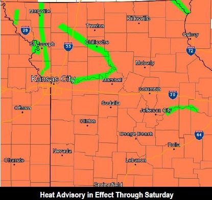
Heat advisory in effect this afternoon and Saturday

A heat advisory is in effect Friday afternoon and Saturday. (National Weather Service graphic)

Hot and humid conditions return for today and Saturday, with a heat advisory in effect from 1 p.m. today until 9 p.m. Saturday in Kansas City, Kan., the National Weather Service said.

Today’s high will be 95, with a heat index as high as 106, according to the weather service.

Saturday’s forecast is a high of 94, with a heat index as high as 106, the weather service said.

The weather will be dangerously hot in the afternoons, according to the weather service. It advised people to take extra precautions if they are spending time outside. Reschedule strenuous activities to early morning or late evening, be aware of the symptoms of heat exhaustion and heat stroke, wear lightweight and loose-fitting clothing when possible, check on relatives and neighbors, and drink plenty of water, the weather service said.

Schedule frequent breaks in the shade or in an air-conditioned room if working outside, the weather service said. Anyone overcome by heat should be moved to a cooler location, and call 911 if it is a heat emergency.
Thunderstorm chances return Saturday night and Sunday, the weather service said. Severe storms are possible Sunday as a front slides south through the area, according to the weather service. Locally heavy rain and additional flooding are possible as well.

The main hazards with storms on Sunday are winds and flooding, according to the weather service. While the threat of a tornado is very low, it can’t be ruled out at this point, the weather service said. Small hail also is possible.

The chance of storms continues through Monday night. Wednesday, there will be a 30 percent chance of rain, according to the weather service.

The severe weather outlook shows Wyandotte County is at slight risk for severe storms on Sunday. (National Weather Service graphic)

Sunny and hot today, rain possible in late afternoon

Severe weather outlook for Thursday. (National Weather Service graphic)

Today’s weather will be sunny with a high near 92, with a chance of rain after 4 p.m., according to the National Weather Service.

The heat index today could reach as high as 100, the weather service said. Winds will be 10 to 14 mph, with gusts as high as 20 mph.

There could be additional flooding to the north today, as thunderstorms were moving north of the Kansas City area, according to the weather service.

Tonight, there is a 30 percent chance of showers and thunderstorms mainly between 7 p.m. and 10 p.m., according to the weather service.

Friday, look for mostly sunny skies with a high near 94, the weather service said. The heat index could be as high as 103. Friday night, the low will be 77.

Saturday, it will be mostly sunny, with a high near 92. A south wind will be from 10 to 16 mph, with gusts as high as 23 mph, according to the weather service.

Saturday night, there will be a 30 percent chance of precipitation, with a low around 76, the weather service said.

Sunday, showers and storms are likely, with a high near 89, the weather service said.

Forecast through Thursday. (National Weather Service graphic)

Storm moves in to area

Cloudy skies at I-70 and K-7 this morning. (KC Scout photo)

Cloudy skies at I-435 and I-70 in Kansas City, Kan., this morning. (KC Scout photo)

Clouds move in at I-35 and 18th Street. (KC Scout photo)

Some photos of the skies from KC Scout as clouds move into Wyandotte County this morning. The largest part of the storms were expected to go through Johnson and Miami counties.