
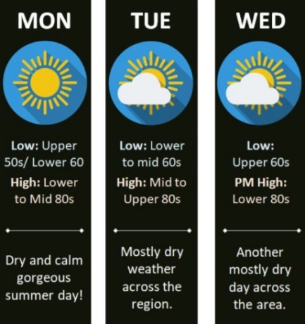
Calm weather, high near 88 today

National Weather Service graphic

This week will see calm and dry weather through Thursday, with today’s high near 88, according to the National Weather Service forecast.

The next chance for thunderstorms could be Thursday afternoon and evening, the weather service said.

A chance of rain is in the forecast for Thursday through Sunday, according to the weather service.

Today, it will be sunny, with a high near 88 and an east southeast wind of 3 to 5 mph, the weather service said.

Tonight, it will be mostly clear, with a low of 66 and an east southeast wind of 3 to 5 mph, according to the weather service.

Tuesday, it will be mostly sunny, with a high near 87 and a calm wind becoming south 5 to 7 mph in the morning, the weather service said.

Tuesday night, it will be mostly clear, with a low of 68 and a south southeast wind of 6 mph, according to the weather service.

Wednesday, it will be mostly sunny, with a high near 88 and a south wind of 5 to 9 mph, the weather service said.

Wednesday night, it will be mostly clear, with a low around 70, according to the weather service.

Thursday, there is a 30 percent chance of showers and thunderstorms after 1 p.m., with a high near 88, the weather service said.

Thursday night, there is a 40 percent chance of showers and thunderstorms after 1 a.m., with a low of 72, according to the weather service.

Friday, there is a 60 percent chance of showers, with thunderstorms also possible after 1 p.m., the weather service said. The high will be near 86.

Friday night, there is a 40 percent chance of showers and thunderstorms, with a low of 70, according to the weather service.

Saturday, there is a 30 percent chance of showers, with a high near 85, the weather service said.

Saturday night, there is a 30 percent chance of showers, with a low of 68, according to the weather service.

Sunday, there is a 30 percent chance of showers, with a high near 88, according to the weather service.
Weather: Much cooler, high of 82 today

National Weather Service graphic
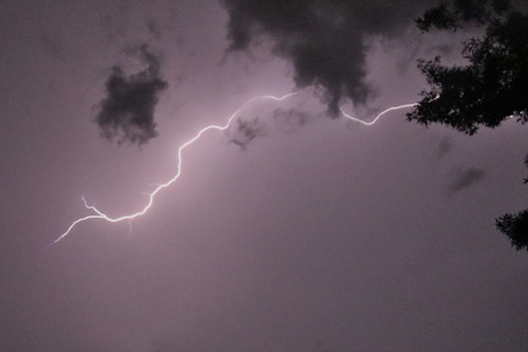
Lightning flashed across the sky on Thursday night, Aug. 12, in Wyandotte County. (Photo by Steve Rupert)
Lightning flashed across the sky on Thursday night, Aug. 12, in Wyandotte County. (Video by Steve Rupert)

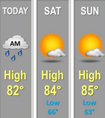
Today’s forecast from the National Weather Service is much cooler, with a high near 82 today.

Ongoing showers and thunderstorms could continue this morning before coming to an end by noon, the weather service said.

Severe weather is not expected, but continued locally heavy rainfall may lead to elevated creeks and streams, according to the weather service.

Southern Wyandotte County, Johnson County and southwestern Leavenworth County were under a flood warning for creeks and streams until 5:45 p.m. Friday.

The Kansas and Missouri rivers in Wyandotte County are below flood stage, according to hydrology reports. Indian Creek in Johnson County and the Blue River in Kansas City, Missouri, were in minor flood stage and action stage Friday morning.

Today, there is a 70 percent chance of showers and thunderstorms, mainly before noon, the weather service said. The high will be near 82 with a west northwest wind of 5 to 7 mph becoming east in the afternoon. Between a tenth and quarter-inch of rain is possible.

Tonight, it will be partly cloudy, with a low of 67 and an east northeast wind of 3 to 6 mph, according to the weather service.

Saturday, it will be mostly sunny, with a high near 84 and an east wind of 3 to 7 mph, the weather service said.

Saturday night, it will be mostly clear, with a low of 64 and an east wind of 3 to 6 mph, according to the weather service.

Sunday, it will be mostly sunny, with a high near 84 and an east southeast wind of 3 to 7 mph, the weather service said.

Sunday night, it will be mostly clear, wth a low of 64, according to the weather service.

Monday, it will be sunny, with a high near 85, the weather service said.

Monday night, it will be mostly clear, with a low of 67, according to the weather service.

Tuesday, it will be mostly sunny, with a high near 87, the weather service said.

Tuesday night, it will be partly cloudy, with a low of 70, according to the weather service.

Wednesday, it will be mostly sunny, with a high near 90, the weather service said.

Wednesday night, there is a 30 percent chance of showers and thunderstorms, with a low of 71, according to the weather service.

Thursday, there is a 40 percent chance of showers with a high near 88, the weather service said.

Flood warning issued for southern Wyandotte County

A flood warning has been issued for southern Wyandotte, according to the National Weather Service.

The flood warning is in effect from 7:39 a.m. Friday through 5:45 p.m. Friday, the weather service said.

The flood warning also is in effect for Johnson County and southwestern Leavenworth County, according to the weather service.

At 7:39 a.m., Doppler radar indicated heavy rain due to thunderstorms, the weather service said. Flooding was ongoing or expected to begin shortly in the area, as between 4 and 6 inches of rain have fallen. Additional rain of up to a half-inch is possible in the warned area, according to the weather service.

Motorists were advised to turn around and not try to cross flooded roads, the weather service said.

The major rivers, Missouri and Kansas rivers, in Wyandotte County are not in flood stage. Some streams in Johnson County, including Indian Creek, were in minor flood stage, with levels currently falling. The Blue River in Kansas City, Missouri, was in the action stage, according to hydrology charts.