Look for much cooler weather today

Cooler temperatures are in the forecast today as a cold front moves through the region this morning, according to the National Weather Service.

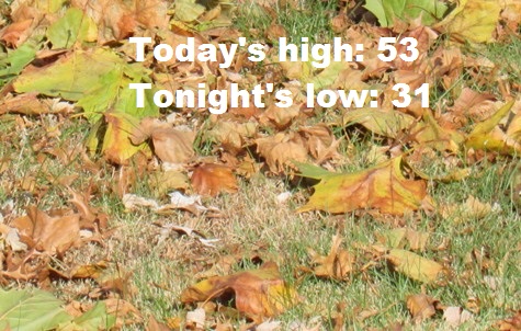
Today’s high will be about 53 degrees, around 20 degrees lower than Tuesday, and tonight’s low will be subfreezing at 31, the weather service said. The temperature was 51 at 9 a.m.

Winds gusting as high as 29, with relative humidity dropping into the 30 percent range this afternoon, will result in slightly elevated fire weather concerns today, according to the weather service.

Today, it will be partly sunny, with a high near 53 and a north wind of 9 to 18 mph, gusting as high as 29 mph, the weather service said.

Tonight, it will be mostly clear, with a low of 31 and a northwest wind of 9 mph, according to the weather service.

Thursday, it will be sunny, with a high near 46 and a west northwest wind of 7 to 14 mph, gusting as high as 18 mph, the weather service said.

Thursday night, it will be mostly clear, with a low of 29, according to the weather service. A west wind of 5 mph will become calm.

Friday, it will be partly sunny, with a high near 51, the weather service said. A south wind of 6 to 14 mph will gust as high as 25 mph.

Friday night, it will be mostly cloudy, with a low of 38, according to the weather service.

Saturday, it will be mostly sunny, with a high near 57, the weather service said.

Saturday night, it will be mostly cloudy, with a low of 40, according to the weather service.

Sunday, it will be partly sunny with a high near 55, the weather service said.

Sunday night, it will be mostly clear, with a low of 28, according to the weather service.

Monday, it will be sunny, with a high near 43, the weather service said.

Monday night, it will be mostly clear, with a low of 29, according to the weather service.

Tuesday, it will be mostly sunny, with a high near 52, the weather service said.

Today’s high near 72

Well above normal temperatures and breezy south-southwesterly winds are in today’s forecast.

Winds may gust as high as 21 mph today, according to the National Weather Service.

Drizzle or light rain is possible along and east of I-35 after 3 a.m. tonight through Wednesday morning, the weather service said.

The temperature will drop to a high of 52 on Wednesday. Cooler, more seasonal temperatures will move in at mid-week, lasting into next weekend, according to the weather service.

Today, it will be mostly sunny, with a high near 72 and a south wind of 9 to 15 mph gusting as high as 21 mph, the weather service said.

Tonight, there is a 30 percent chance of rain, mainly after 3 a.m., with a low of 48, according to the weather service. A south wind of 7 to 14 mph will become north after midnight. Winds may gust as high as 20 mph. Less than a tenth of an inch of rain is possible.

Wednesday, there is a 20 percent chance of rain before noon, with a high near 52, the weather service said. A north wind of 10 to 17 mph will gust as high as 31 mph.

Wednesday night, it will be mostly cloudy, then gradually clearing, with a low of 30, according to the weather service. A west northwest wind will be 6 to 8 mph.

Thursday, it will be sunny, with a high near 46 and a northwest wind of 5 to 10 mph becoming light west northwest in the afternoon, the weather service said. Winds may gust as high as 21 mph.

Thursday night, it will be mostly clear, with a low of 28, according to the weather service.

Friday, it will be partly sunny, with a high near 50, the weather service said.

Friday night, it will be mostly cloudy, with a low of 39, according to the weather service.

Saturday, it will be mostly sunny, with a high near 56, the weather service said.

Saturday night, it will be partly cloudy with a low of 36, according to the weather service.

Sunday, it will be mosty sunny, with a high of 53, the weather service said.

Sunday night, it will be partly cloudy, with a low of 30, according to the weather service.

Monday, it will be sunny, with a high near 45, the weather service said.

Today’s high near 67

Today, temperatures will approach 67 as the weather stays dry in the Wyandotte County area.

Tuesday, look for more dry weather as the high approaches 70, according to the weather service.

Wednesday will see a shift to a slight chance of rain before noon, and the high reaching only 52, the weather service said.

With the cold front moving in, temperatures will be stuck in the 40s and 50s throughout the area, according to the weather service. Light rain may be possible south and east of the I-35 corridor. Temperatures may drop below freezing Wednesday night and Thursday nights.

Today, it will be sunny with a high near 67 and a southwest wind of 7 to 15 mph, gusting as high as 21 mph, the weather service said.

Tonight, it will be mostly clear, with a low of 45 and a southwest wind of around 7 mph, according to the weather service.

Tuesday, it will be mostly sunny, with a high near 70, the weather service said. A south wind of 7 to 15 mph will gust as high as 22 mph.

Tuesday night, there is a 20 percent chance of rain after midnight, with a low of 46, according to the weather service. A south wind of 6 to 14 mph will become north after midnight. Winds may gust as high as 20 mph.

Wednesday, there is a 20 percent chance of rain before noon, with a high near 52, the weather service said. A north wind of 7 to 13 mph will gust as high as 24 mph.

Wednesday night, it will be partly cloudy, with a low of 31, according to the weather service.

Thursday, it will be sunny, with a high near 48, the weather service said.

Thursday night, it will be partly cloudy, with a low of 29, according to the weather service.

Friday, it will be partly sunny, with a high near 51, the weather service said.

Friday night, it will be mostly cloudy, with a low of 39, according to the weather service.

Saturday, it will be partly sunny, with a high near 54, the weather service said.

Saturday night, it will be partly cloudy, with a low of 36, according to the weather service.

Sunday, it will be mostly sunny, with a high near 53, the weather service said.