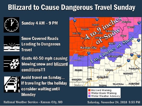
The National Weather Service has issued a blizzard warning for Wyandotte County from 9 a.m. Sunday, Nov. 25, until 9 p.m. Sunday, Nov. 25.
Blizzard conditions and very dangerous travel are expected, the weather service said.
A very strong storm system will track across the region from early Sunday morning through Sunday evening, the weather service said.
Rain will quickly change to snow, with snow falling at faster than one inch per hour at times, according to the weather service.
The heaviest snow is expected to be north of I-70, where 5 to 9 inches of snow are possible, the weather service said.
Along and south of I-70, lower snow totals in the 1 to 5-inch range are possible, according to the weather service.
Strong wind gusts of up to 45 mph are possible, the weather service said.
The combination of heavy snow and strong winds will lead to white-out-conditions and very dangerous travel on area roadways, according to the weather service.
Travel across the region on Sunday is highly discouraged, the weather service said.
The Sunday forecast for Wyandotte County, as of Saturday night, includes rain before 8 a.m., then rain and snow between 8 a.m. and 9 a.m., then snow after 9 a.m., the weather service said.
Patchy blowing snow is possible after noon, according to the weather service. The temperature will fall to about 25 by 5 p.m. A north northwest wind of 16 to 26 mph may gust as high as 40 mph.
New snow accumulation of 2 to 4 inches is possible in Wyandotte County, according to the weather service. From 3 to 5 inches of snow are possible on the north side of Wyandotte County.
For weather updates, visit www.weather.gov.