Some roadways in the region are considered slick this morning, according to the National Weather Service.
Sleet and snow fell across the area overnight and melted quickly because of the warm pavement.
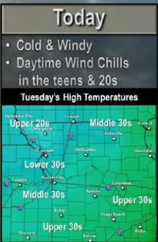
Gusty northerly winds continue to usher in very cold air, as temperatures this morning are generally in the middle 20s to lower 30s.
This steady stream of cold air could cause some roadways to become very slick especially elevated roadways, overpasses and bridges where warm ground temperatures fail to keep those roadways warm enough to prevent icing.
The National Weather Service cautioned drivers to use extreme caution during the morning commute.
Temperatures should rise back to near freezing by this afternoon, but only for a few hours before dropping back to below freezing for this evening.
Wind chill values were in the single digits this morning, with values in the teens throughout the day. Single-digit wind chill values are likely again tonight.
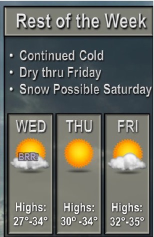
There is a chance for snow on Saturday. Light accumulations are possible at this time.
Temperatures were 28 degrees at 8 a.m., and today’s high is predicted to be 32 degrees. Skies will be sunny. Winds will be 15 to 18 mph with gusts of 30 mph.
Tonight, the low will be around 19, and a north northwest wind will be around 14 mph, with gusts of 21 mph.
Wednesday, it will be partly sunny with a high near 29. The wind will be 11 to 14 mph, with gusts of 20 mph.
Saturday and Saturday night, there is a 40 percent chance of rain and snow, and the high Saturday will be near 40 degrees in the day. The low Saturday night will be around 21.