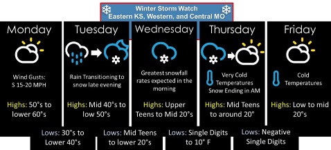
Look for a high today near 60 in Wyandotte County before a predicted winter storm moves in late Tuesday night and Wednesday, according to the National Weather Service forecast.
Southerly winds today will draw in warmer air ahead of the midweek storm, the weather service said.
Big changes are in the forecast for Tuesday, as a cold front moves through the area, according to the weather service.
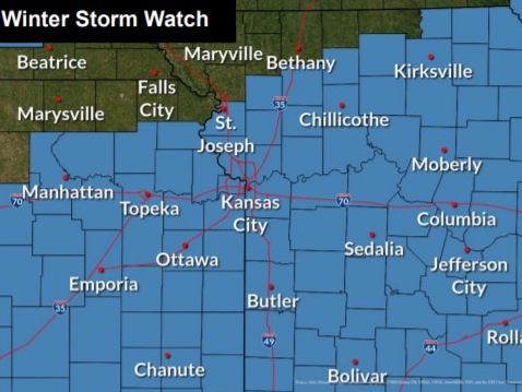
Wyandotte County and surrounding areas are under a winter storm watch, in effect from Tuesday evening through Thursday afternoon, the weather service said.
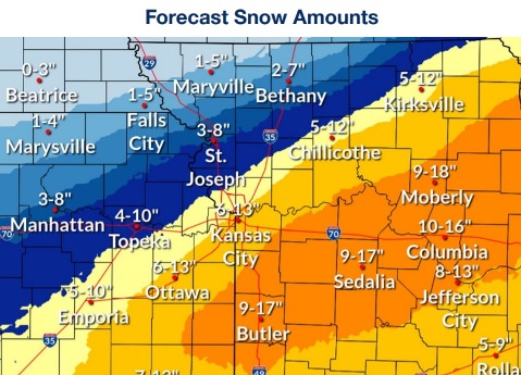
Heavy snow is possible, with accumulations of 2 to 4 inches on Wednesday, and snow also possible late Tuesday night and Wednesday night. A total of 6 to 12 inches is possible in the Kansas City area, according to the weather service.
However, forecasters said there is a great deal of uncertainty in the forecast at this time, and parts of the Kansas City area could be on the borderline between significant amounts of snow and minimal amounts. The north side of the area may get the heaviest amount of snow. Residents may follow updated later forecasts at www.weather.gov.
The weather service said travel could be very difficult to impossible with this winter storm. Hazardous conditions could affect morning and evening commutes.
There will be very cold temperatures on Thursday night, falling to minus 3, according to the weather service.
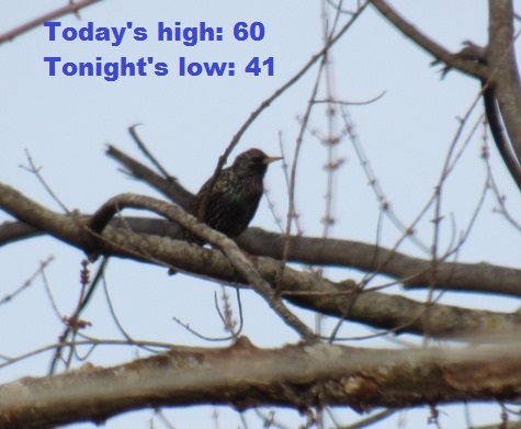
Today, it will be mostly sunny, with a high near 60, the weather service said. A south southwest wind of 5 to 11 mph may gust as high as 22 mph.
Tonight, there is a 20 percent chance of rain between 3 a.m. and 4 a.m., with a low of 41, according to the weather service. A south wind of 6 to 13 mph will become west after midnight. Winds may gust up to 23 mph.
Tuesday, there is a 30 percent chance of rain, with a high near 50, the weather service said. A northwest wind of 6 to 10 mph will become north northeast in the afternoon. Winds may gust as high as 20 mph. Less than a tenth of an inch of precipitation is forecast.
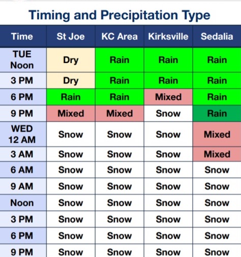
Tuesday night, there is an 80 percent chance of rain before 9 p.m., then a chance of rain and snow between 9 p.m. and 10 p.m., then snow after 10 p.m., according to the weather service. The low will be around 18 with a north northeast wind of 10 to 14 mph, gusting as high as 21 mph. Less than an inch of snow accumulation is in the forecast.
Wednesday, there is an 80 percent chance of snow, with a high near 22, the weather service said. A north northeast wind of 14 to 16 mph will gust as high as 24 mph. New snow accumulation of 2 to 4 inches is in the forecast.
Wednesday night, there is a 60 percent chance of snow, mainly before midnight, according to the weather service. The low will be around 8.
Thursday, it will be partly sunny, with a high near 18, the weather service said.
Thursday night, it will be partly cloudy, with a low of minus 3, according to the weather service.
Friday, it will be sunny, with a high near 24, the weather service said.
Friday night, it will be mostly clear, with a low of 10, according to the weather service.
Saturday, it will be sunny, with a high near 35, the weather service said.
Saturday night, it will be partly cloudy, with a low of 19, according to the weather service.
Sunday, it will be mostly sunny, with a high near 41, the weather service said.