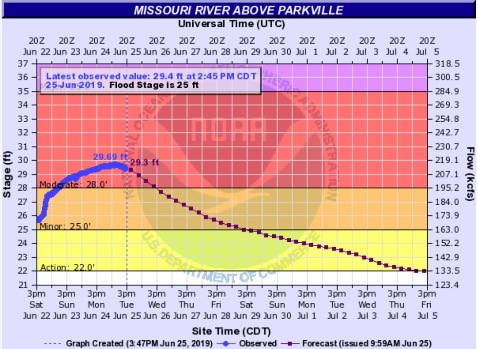
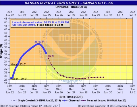
Levels of the Missouri and Kansas rivers crested earlier today in Wyandotte County and are now declining, according to a forecaster with the National Weather Service.
The two rivers were in flood stage here today, with the Missouri at moderate flood stage and the Kansas at minor flood stage, after heavy weekend rains.
Although there was a possibility of rain in the forecast tonight in the Kansas City area, the next several days will be dry, except for possible occasional showers.
An emergency flood fight is currently underway in Holt County, Missouri, according to Rick Weixelbaum, emergency management specialist with the Kansas City District, U.S. Army Corps of Engineers. He spoke during a news conference today. The corps is assisting in the flood fight, and efforts include placing rock on a levee embankment.
Several rivers are currently flooding in Kansas and Missouri as a result of recent rains, according to a hydrologist for the Kansas City district.
Significant rainfalls over the past weekend raised the flood control pools to 90 percent in the lower Kansas basin, according to officials. Some of the reservoirs experienced an increase of 9 percent or more.
Milford reservoir was increased from a low flow release to 5,000 cfs today, with the travel time more than four days to the Missouri River, officials said. Levels at Waverly, Missouri, should recede before these new flows reach it, according to officials.
Tuttle Creek is going from a low flow to a 5,000 cfs release today, and it will take more than three days to reach the Missouri River.
Perry releases will go from 1,000 cfs to 2,000 cfs, officials said.
In the Osage basin, Truman reservoir is forecast to release water at 45,000 cfs, maintaining that level until conditions change. Releases were reduced from some reservoirs in the Osage basin over the weekend, with the heavy rains, but those releases now are being increased again, according to officials. Melvern is releasing 1,000 cfs.
During a question-and-answer session, a representative of districts including the Elwood-Gladden Drainage District in Doniphan County, Kansas, which is not far from the St. Joseph, Missouri, area, told the corps that they can’t keep up with pumping and they need the corps to reduce flows for several days from Gavins Point.
“Some of my smaller districts are about out of money to continue pumping,” the drainage district representative said. He asked the corps to reduce Gavins Point reservoir flows substantially for several days, possibly to 30,000 cfs, and then pick it back up again.
In South Dakota, the corps is still on track to reduce releases from the Gavins Point dam into the Missouri River from 75,000 cfs to 70,000 on Thursday, according to officials. However, that will be reassessed on Wednesday and the numbers could change based on conditions, officials said.
A corps official told the drainage district representative that they have more than 8.5 million acre feet of water stored upstream in the reservoirs currently at Gavins Point and above, are adding 15,000 to 20,000 acre feet a day, and will continue to add as the mountain snowpack hits the reservoirs hard. He said it’s not going to be possible to reduce the Gavins Point flows substantially, but the corps is discussing possible options for short-term relief today and this week.
“Everybody downstream understands,” the drainage district representative said. “But at some point we have to have a break. We don’t have the capability to mechanically pump this water.”
The drainage district representative stated that they have a half-million dollars worth of infrastructure in homes and businesses that they are protecting.