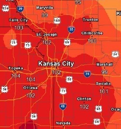
Hot weather again is in today’s forecast, with a heat index as high as 103 predicted for Wyandotte County, according to the National Weather Service.
Highs will climb back into the middle 90s Tuesday and Wednesday, according to the weather service, before a cold front with thunderstorms moves in Wednesday afternoon and evening, into Thursday.
Some of the storms may be strong to severe, with damaging winds the primary threat, the weather service said.
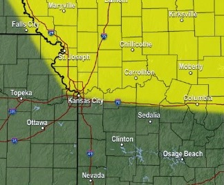
An air quality alert has been issued for Tuesday, July 25, by the Mid-America Regional Council, and people and businesses are asked to avoid activities that lead to ozone formation.
The weather service said residents should try to avoid refueling vehicles or topping off when refueling idling vehicles unnecessarily, and avoid using gasoline-powered lawn equipment.
Also, residents are asked to carpool, bike to work, delay or combine errands and use water-based paints and cleaners.
Residents should consider limiting strenuous outdoor physical activity to reduce the risk of adverse health effects, according to the weather service. The very young and those with pre-existing respiratory problems such as asthma and heart disease should be especially careful.
Today, it will be sunny with a high of 93 and a heat index as high as 103, the weather service said. There will be a south wind of 6 to 9 mph.
Tonight, it will be mostly clear with a low of 76, and a south southeast wind of 6 to 8 mph, according to the weather service.
Wednesday, there is a 20 percent chance of showers and thunderstorms after 1 p.m., according to the weather service, with a low of 75. It will be mostly sunny with a high near 95, and a heat index as high as 106. A south wind will be 5 to 9 mph.
Wednesday night, there is a 50 percent chance of showers and storms, with a low of 75, and a south wind of 6 to 8 mph becoming west after midnight, according to the weather service. Between a tenth and quarter-inch of rain is possible.
Thursday, there is a 30 percent chance of showers and thunderstorms, mainly before 1 p.m., the weather service said. There will be a north wind of 5 to 9 mph.
Thursday night, it will be partly cloudy with a low of 67, according to the weather service.