The first round of storms left a little ice and a dusting of snow on Wyandotte County, but a second round could arrive later, according to the National Weather Service, which has placed Wyandotte County and the surrounding region under a winter storm warning until 9 p.m. tonight.
Freezing rain and sleet are possible before 2 p.m., followed by snow today, the weather service said.
Today’s high will be near 32. It will be windy, with a north northeast wind of 18 to 26 mph, and gusts as high as 38 mph, the weather service said.
The chance of precipitation today is 90 percent, the weather service said. Around one inch total daytime snow and sleet accumulation is possible today.
Tonight, there is a 20 percent chance of snow before 9 p.m., according to the weather service. The low will be around 21, with a west wind of 9 to 18 mph, gusting as high as 25 mph.
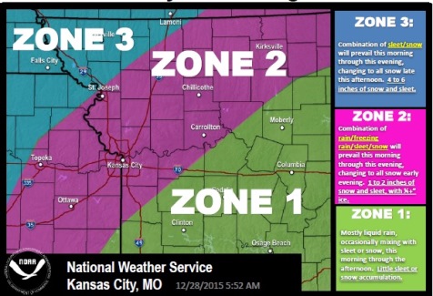
Temperatures will be cold enough later tonight and Monday to allow some freezing rain to develop as precipitation moves back to the north, with a transition to sleet and snow to follow Monday afternoon as temperatures continue to drop, according to the weather service.
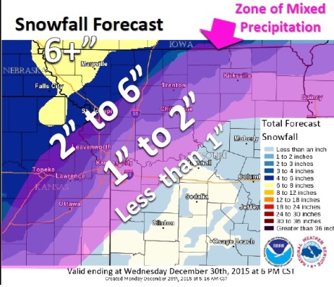
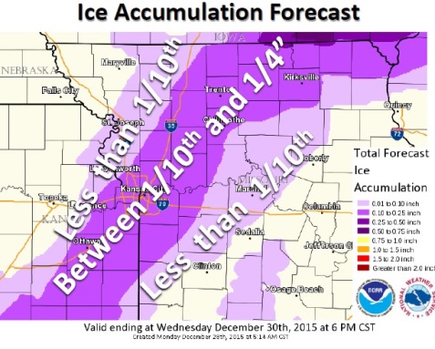
Highest snow accumulations are expected to be across the far northwest corner of Missouri with the highest ice accumulation from St. Joseph to Kirksville, according to the weather service.
Notable ice-sleet-snow accumulations are not expected to develop until after sunset tonight, the weather service said.
Flooding of creeks and rivers will be possible across much of the region, mostly in the central part of the Missouri, the weather service said.
Snowfall amounts will be highest across far northwest Missouri, far northeast Kansas, and into Iowa and Nebraska, where 3 to 6 inches of snow is possible through this evening with a little sleet mixed in.
More sleet and freezing rain will mix in with the snow farther south and east, the weather service said.
Periods of freezing rain will remain possible this morning into this evening across areas roughly from Ottawa, Kan., through Kansas City, Mo., to Trenton, Mo., and Kirksville, Mo., the weather service said.
This freezing rain will likely mix with sleet and snow through the day, according to the weather service.
Tuesday, expect mostly cloudy skies with a high of 27, according to the weather service, and a west wind of 6 to 8 mph. Tuesday night, there is a 30 percent chance of snow after midnight. The low will be 18.
Wednesday, skies will be mostly sunny with a high of 27, the weather service said, and a west northwest wind of 5 to 8 mph.
The New Year’s Eve forecast, Thursday night, will be partly cloudy with a low of 13, the weather service said. New Year’s Day will be mostly sunny with a high near 27.
The weather service warned that travel may become hazardous during the winter storm. For the latest road conditions, call 5-1-1. In Kansas, visit www.kandrive.org/ for road conditions. In the Kansas City area, visit http://www.kcscout.net/.