The weather will be in the 30s today and the 20s on Saturday, before it goes back to the mid-40s on Sunday, according to the National Weather Service.
Overnight lows will drop into the single digits, with wind chills below zero, the weather service said.
Today, it will be mostly sunny with a high near 33, and a north wind of 10 to 13 mph, gusting to 18 mph, according to the weather service.
Tonight, it will be partly cloudy with a low of 8, and wind chill between minus 2 and 3, according to the weather service. The north wind will be 7 to 10 mph.
Saturday, expect mostly cloudy skies and a high near 24. Wind chill values will be between minus 3 and 7, the weather service said. An east southeast wind of 7 to 9 mph is in the forecast.
Saturday night, it will be mostly cloudy with a low of 23, and an east southeast wind of around 10 mph, according to the weather service.
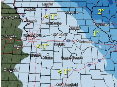
Snow is possible east of the Kansas City, Kan., area for Saturday night into Sunday. While it is not listed in the Kansas City, Kan., area, a very slight chance of snow appears on National Weather Service maps.
Sunday, the temperatures go up to a high of 45 with partly sunny skies, the weather service said. A south wind of 6 to 10 mph will become west southwest in the afternoon.
Sunday night, the low will be around 30, according to the weather service.
On Monday, Presidents Day, skies will be mostly sunny with a high near 51, the weather service said. Monday night’s low will be around 34.
Tuesday, the high will be near 53, with mostly sunny skies, according to the weather service.
Wednesday’s high will be near 51, and Thursday’s high will be about 62, the weather service said.