Saturday’s heat index could reach 101 as temperatures hit a high of 95, according to the National Weather Service forecast. Storms are in the forecast late tonight and Sunday.
Look for the heat index to hit 100 around 2 p.m. Saturday, and about 101 at 4 p.m.
Hot weather also is in store on Monday and Tuesday, the weather service said.
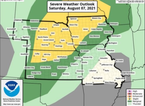
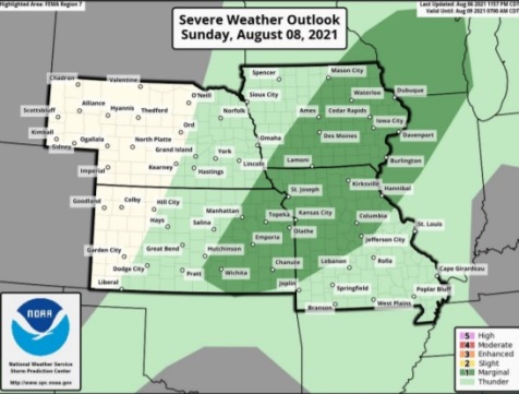
Wyandotte County is on the edge of an area that may experience strong or isolated severe storms tonight and Sunday, the weather service said.
Strong winds are the main concern of this storm, according to the weather service. Storms also are possible Sunday and Sunday night, with wind, hail and heavy rain possible in areas.
With smoke from the western wildfires overspreading the region, today there is a moderate air quality index reading. Those who are sensitive to air pollution could be at risk.
Today, it will be mostly sunny with a high near 95, the weather service said, and heat index values as high as 101. A south wind of 10 to 16 mph will gust as high as 23 mph.
Tonight, there is a 20 percent chance of precipitation after 5 a.m. The low will be around 76 with a south wind of 10 to 14 mph, gusting as high as 18 mph, according to the weather service.
Sunday, there is a 40 percent chance of showers and thunderstorms, mainly after 7 a.m., the weather service said. The high will be near 91 with a south southwest wind of 10 to 13 mph, gusting as high as 25 mph. Between a tenth and quarter-inch of rain is possible.
Sunday night, there is a 30 percent chance of showers and thunderstorms, mainly before 1 a.m., according to the weather service. The low will be around 75 with a south southwest wind around 10 mph, gusting as high as 20 mph. Between a tenth and quarter-inch of rain is possible.
Monday, it will be sunny, with a high near 96 and a south southwest wind of 11 mph, gusting as high as 18 mph, the weather service said.
Monday night, there is a 20 percent chance of showers and thunderstorms after 1 a.m., with a low of 77, according to the weather service.
Tuesday, it will be mostly sunny, with a high near 95, the weather service said.
Tuesday night, there is a 50 percent chance of showers, with thunderstorms also possible after 1 a.m., according to the weather service. The low will be around 75.
Wednesday, there is a 30 percent chance of showers after 1 p.m., with a high near 93, the weather service said.
Wednesday night, it will be mostly clear, with a low of 73, according to the weather service.