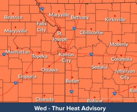
A heat advisory continues in Wyandotte County through 9 p.m. Thursday, July 29, according to the National Weather Service.
There will be dangerously hot conditions this week, the weather service said.
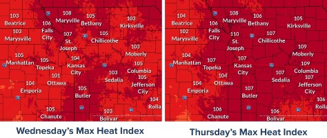
Today, the temperature may reach 97, with a heat index of 105, according to the weather service.
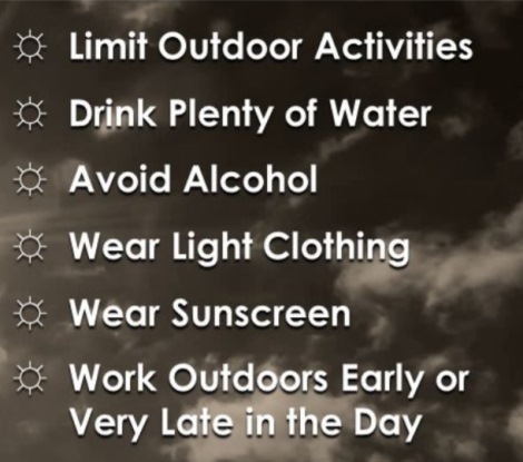
Residents are advised to avoid outdoor activities during the afternoon hours. Stay hydrated, wear light-colored and lightweight clothing.
A front will move into the area Friday with hot and muggy conditions continuing to the south.
There is also an air quality alert in effect for Wednesday, issued by the Mid-America Regional Council. Ozone is the primary pollutant.
People and businesses are urged to avoid activities that lead to ozone formation. Individuals should consider limiting physical activity to reduce the risk of adverse health effects.
Cooling centers in Wyandotte County are listed online by the Unified Government at https://unifiedgov.maps.arcgis.com/apps/LocalPerspective/index.html?appid=05d96f432cd645f6a59512875df09d6b.
Today, it will be sunny and hot, with a high near 97 and a heat index as high as 105, the weather service said. A south wind will be 3 to 7 mph.
Tonight, it will be mostly clear, with a low of 75 and a south wind of 6 mph, according to the weather service.
Thursday, it will be sunny and hot, with a high near 98 and a heat index of 107, the weather service said. A west southwest wind will be 6 to 8 mph.
Thursday night, it will be partly cloudy, with a low of 76 and a southwest wind of 6 mph becoming calm in the evening, according to the weather service.
Friday, there is a 20 percent chance of showers and thunderstorms after 1 p.m., the weather service said. The high will be near 94 with a calm wind becoming southeast around 6 mph in the afternoon.
Friday night, there is a 30 percent chance of showers and thunderstorms after 1 a.m., according to the weather service. The low will be around 74. Between a quarter and half-inch of rain is possible.
Saturday, there is a 50 percent chance of showers and thunderstorms, with a high near 86, the wether service said.
Saturday night, there is a 40 percent chance of showers and thunderstorms, with a low around 68, according to the weather service.
Sunday, it will be mostly sunny with a high near 86, the weather service said.
Sunday night, it will be mostly clear, with a low of 64, according to the weather service.
Monday, it will be sunny, with a high near 84, the weather service said.
Monday night, it will be mostly clear, with a low of 63, according to the weather service.
Tuesday, it will be sunny, with a high near 85, the weather service said.