A severe thunderstorm watch has been issued until 9 p.m. Friday for Wyandotte County and the surrounding area, according to the National Weather Service.
The watch is in effect for Leavenworth and Johnson counties, as well as many other counties in Kansas.
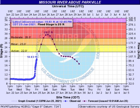
The weather service also has issued a flood warning for the Missouri River at Parkville, where the gauge is on the Missouri River at I-435 between Wyandotte and Platte counties.
The forecast has changed from minor to moderate severity and has increased in duration for the Missouri River, according to the weather service.
The Wolcott area in northwestern Kansas City, Kansas, is near the area for the Missouri River above Parkville.
At 12:45 p.m. Friday, the Missouri River above Parkville was rising swiftly and was at 18.83 feet, where action stage is at 22 feet and flood stage is at 25 feet.
Hydrology charts predicted the river would rise to the moderate flooding level, 29.7 feet, on Saturday, according to the USGS and NOAA chart.
Motorists should not try to drive around barricades or drive their cars through flooded areas, the weather service said.
Be especially cautious at night when it is harder to see. When encountering flooded roads, turn around and take another route, the weather service said.
For more weather information, visit www.weather.gov.