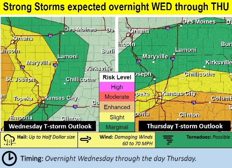
A large complex of thunderstorms will move in to the area from the northwest on Wednesday night and Thursday morning, according to the National Weather Service forecast.
Thunderstorms are expected to persist into Thursday morning
Storms may arrive around midnight, and bring heavy rain leading to local flooding and strong winds, the weather service said.
There is some uncertainty about the storms on Thursday afternoon, as it is highly dependent on how storms behave Thursday morning, according to the weather service.
More strong thunderstorms are expected during the afternoon should there be a break in the rain mid-morning Thursday, the weather service said.
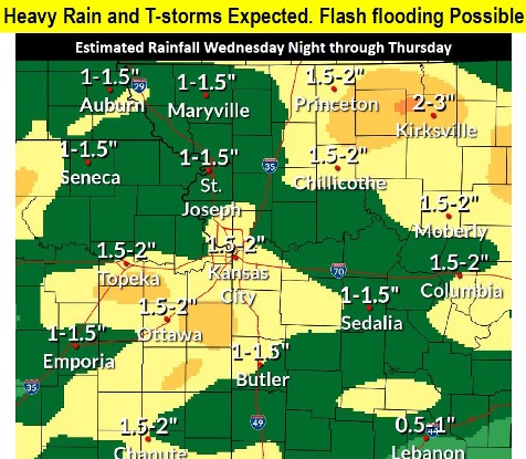
Heavy rain, flash flooding, frequent lightning and gusty winds remain the primary hazards, according to the weather service. Hail and an isolated tornado are also possible.
Flash flooding is possible especially on impervious surfaces such as roads and parking lots, the weather service said.
Stream flooding remains a concern as more rain moves into areas that have saturated soils and already-swollen streams, according to the weather service. On Wednesday morning, the rivers in Wyandotte County were well below flood and action stage, according to NOAA and USGS hydrology charts.
Today, it will be sunny, with a high near 85, the weather service said. A west wind around 5 mph will become calm.
Tonight, there is an 80 percent chance of showers and thunderstorms, mainly after 4 a.m., according to the weather service. Some of the storms may be severe and produce heavy rainfall. The low will be around 68 with a south southeast wind of 8 mph. Between a tenth and quarter inch is possible.
Thursday, there is a 90 percent chance of showers and thunderstorms, according to the weather service. Some of the storms could be severe and produce heavy rainfall. The high will be near 78 with a south southwest wind of 11 to 16 mph, gusting as high as 24 mph. Between 1 and 2 inches are possible.
Thursday night, there is an 80 percent chance of showers and thunderstorms, mainly before 7 p.m., according to the weather service. Some of the storms could be severe. The low will be around 52 with a west wind of 8 to 10 mph becoming north in the evening. Less than a tenth of an inch of rain is possible.
Friday, it will be partly sunny, with a high near 65 and a north wind of 8 to 10 mph, gusting as high as 20 mph, the weather service said.
Friday night, it will be mostly cloudy, with a low of 48, according to the weather service.
Saturday, it will be mostly sunny, with a high near 68, the weather service said.
Saturday night, it will be partly cloudy, with a low of 50, according to the weather service.
Sunday, there is a 30 percent chance of showers after 1 p.m., with a high near 72, the weather service said.
Sunday night, there is a 30 percent chance of showers, with a low of 57, according to the weather service.
On Monday, Memorial Day, there is a 50 percent chance of showers, with a high near 72, the weather service said.
Monday night, there is a 40 percent chance of showers, with a low of 59, according to the weather service.
Tuesday, there is a 40 percent chance of showers, with a high near 73, the weather service said.
For more weather information, visit www.weather.gov.