Below normal temperatures are expected this week, with the potential for frost through Thursday morning, mainly for areas north of I-70, according to the National Weather Service.
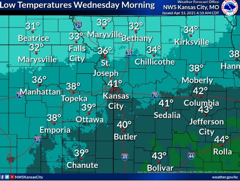
The low could drop to around 39 on Wednesday morning in Wyandotte County, according to the weather service forecast.
Friday will be the next chance for rain, with no hazardous weather expected, the weather service said.
Today, it will be mostly sunny, with a high near 60 and a northwest wind of 5 to 9 mph, the weather service said.
Tonight, it will be mostly cloudy, then gradually becoming mostly clear, with a low of 39, according to the weather service. A northwest wind will be around 6 mph, becoming calm in the evening.
Wednesday, it will be sunny, with a high near 58 and a north northwest wind of 5 to 13 mph, gusting as high as 20 mph, the weather service said.
Wednesday night, it will be mostly clear, with a low around 36 and a north wind of 5 to 10 mph, becoming light after midnight, according to the weather service.
Thursday, it will be mostly sunny, with a high near 59 and a calm wind becoming north 5 to 7 mph in the morning, the weather service said.
Thursday night, there is a 30 percent chance of showers after 1 a.m., with a low of 42, according to the weather service.
Friday, there is a 40 percent chance of showers, with a high near 52, the weather service said.
Friday night, it will be mostly cloudy, with a low of 41, according to the weather service.
Saturday, it will be mostly cloudy, with a high near 55, the weather service said.
Saturday night, it will be mostly cloudy, with a low of 37, according to the weather service.
Sunday, it will be mostly sunny, with a high near 59, the weather service said.
Sunday night, it will be mostly clear, with a low of 39, according to the weather service.
Monday, it will be sunny, with a high near 62, the weather service said.