Dangerously cold temperatures registered at minus 1 at 6 p.m. Sunday, with a wind chill of minus 19, according to the National Weather Service.
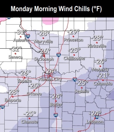
The weather service said wind chills could range from about minus 20 to minus 30.
According to the weather service, there could be slippery road conditions, affecting the Monday morning or evening commute. Cold wind chills can cause frostbite on exposed skin in as little as 20 minutes, the weather service said.
The weather service advised residents to avoid outside activities if possible. When outside, make sure you wear appropriate clothing, a hat and gloves.
Also, motorists should slow down and use caution while traveling, according to the weather service.
For a list of warming centers, visit https://wyandotteonline.com/additional-warming-centers-open-in-kck/.
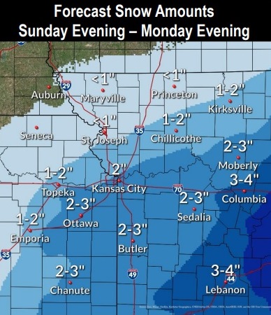
Snow is likely Sunday evening and overnight, the weather service said.
A steadier but light snow is expected during the day Monday, according to the weather service.
An additional 2 to 3 inches of snow is possible through Monday evening, mainly along and south of the Missouri River, with lesser amounts further north, the weather service said.
For the coming week, Monday’s high will be near 0, Tuesday’s high near 12, Wednesday’s high near 22, Thursday’s high near 21, Friday’s high near 33 and Saturday’s high near 40.
Tonight, there is a 60 percent chance of snow, mainly before 8 p.m., according to the weather service. The low will be minus 9, with a wind chill between minus 18 and minus 24. A north wind of 9 to 13 mph is forecast. Total nighttime snow accumulation is expected to be less than one inch.
Monday, Presidents Day, there will be a 60 percent chance of snow, mainly before 11 a.m., the weather service said. It will be mostly cloudy and cold, with a high near 0. The wind chill will be between minus 17 and minus 25. There will be a north wind of 9 to 11 mph. New snow accumulation of 1 to 2 inches is possible, the weather service said.
Monday night, there is a 20 percent chance of snow before midnight, then gradually becoming mostly clear, with a low of minus 12, according to the weather service. The wind chill will be between minus 15 and minus 20. A north wind of 5 to 9 mph will become light after midnight.
Tuesday, it will be mostly sunny and cold, with a high near 12, the weather service said. The wind chill will be between minus 1 and minus 11. A calm wind will become east southeast around 5 mph in the afternoon.
Tuesday night, there is a 40 percent chance of snow, mainly after midnight, with a low around 6, according to the weather service. An east wind will be around 6 mph.
Wednesday, it will be cloudy, with a high near 22, the weather service said.
For more weather information, visit www.weather.gov.