
Snow and bitter cold weather have descended on Wyandotte County on Sunday, Feb. 7.
The snow may last through the afternoon and evening, moving from west to east, according to the National Weather Service.
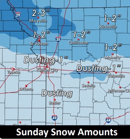
Motorists should slow down on streets and highways, which could contain slick spots.
The wind chill at noon Sunday was minus 8, and the temperature was 6 degrees, according to the weather service.
There will be another chance for light snow with 1 to 2 inch accumulation Monday across far northern Missouri, mainly north of Highway 36.
The stretch of sub-freezing temperatures is expected to last through the week, into next weekend. This will be a significant stretch of sub-freezing temperatures that may last into the middle part of February.
Today, the high will be near 16, and an east wind will be about 9 mph. Less than one inch of snow is expected.
Tonight, there is a 20 percent chance of snow before 9 p.m., then a slight chance of snow after midnight, according to the weather service. The low will be around 9, with a northeast wind of 7 to 9 mph.
Monday, there is a 40 percent chance of snow, mainly before noon, with a high near 18 and a wind chill of minus 1 to 7, the weather service said.
Monday night, the low will be around 6 with a wind chill between minus 2 and 3, with a north northeast wind of 8 mph, according to the weather service.
Tuesday’s high will be about 20, with a northeast wind of 7 to 9 mph.