Snow is expected to continue today, according to the National Weather Service.
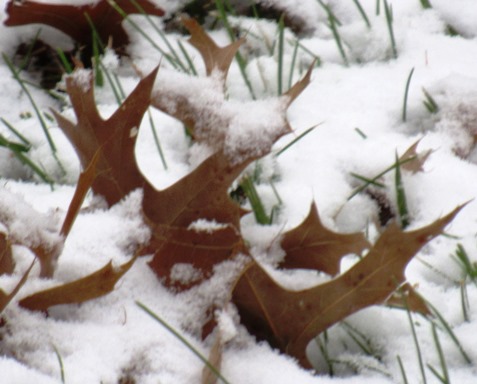
The first snow of the season left an inch or less on local lawns and surfaces in the early morning hours Monday.
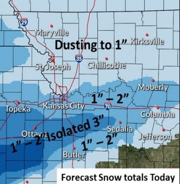
Snow is expected to continue today, tonight and Tuesday morning, with one-half to an inch of accumulation possible, especially on grassy and elevated surfaces, the weather service said.
Light accumulation is possible on roads, creating some slick spots, according to the weather service.
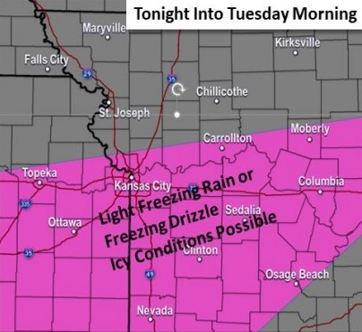
Snow should come to an end after sunset this evening, with a chance for some light freezing rain and freezing drizzle south of the Missouri River tonight through Tuesday morning, the weather service said. Light glazing will be possible, leading to slick traveling conditions.
Temperatures are expected to rise above freezing Tuesday afternoon, with freezing rain and drizzle changing over to rain, according to the weather service.
A hard freeze is expected tonight, with low temperatures dropping into the 20s across the area, the weather service said. This will effectively end the growing season.
Look for heavy rain on Wednesday night, and temperatures in the 50s on Friday.
Today, there is an 80 percent chance of snow before 4 p.m., then more snow, possibly mixed with freezing rain, the weather service said. The high will be near 30 with a north wind of 10 to 13 mph. Little or no ice accumulation is expected. Around an inch of snow is possible during the daytime.
Tonight, there is a 30 percent chance of snow and freezing rain before 10 p.m., then a slight chance of snow between 10 p.m. and 4 a.m., according to the weather service. The low will be around 26 with a north wind of 8 mph. Less than a tenth of an inch of precipitation is possible.
Tuesday, there is a 30 percent chance of snow between 7 a.m. and 1 p.m., then a chance of rain after 1 p.m., the weather service said. The high will be near 38 with a north wind of 5 to 7 mph becoming calm in the afternoon. Less than a tenth of an inch of rain is possible.
Tuesday night, it will be mostly cloudy, with a low of 30 and a calm wind, according to the weather service.
Wednesday, there is a 40 percent chance of rain after 1 p.m., with a high near 49, the weather service said. A calm wind will become east northeast around 6 mph in the afternoon. Less than a tenth of an inch of precipitation is expected.
Wednesday night, there is a 70 percent chance of rain, possibly heavy at times, according to the weather service. The low will be around 40. Between 1 and 2 inches of rain is possible.
Thursday, there is a 60 percent chance of rain, mainly before 1 p.m., the weather service said. The high will be near 48.
Thursday night, it will be partly cloudy, with a low of 33, according to the weather service.
Friday, it will be sunny, with a high near 54, the weather service said.
Friday night, it will be mostly clear, with a low of 37, according to the weather service.
Saturday, it will be sunny, with a high near 59, the weather service said.
Saturday night, it will be mostly clear, with a low of 40, according to the weather service.
Sunday, it will be mostly sunny, with a high near 59, the weather service said.
For more information, visit www.weather.gov.