Today’s forecast from the National Weather Service includes possible storms tonight, and a wind advisory from 9 a.m. to 5 p.m.
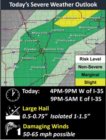
A strong cold front with storms will move through the area in the evening, and some storms could develop with severe wind gusts and large hail, the weather service said.
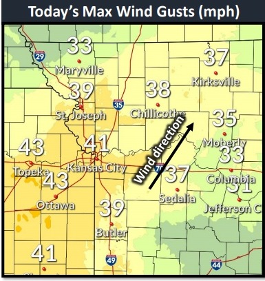
Winds may gust as high as 43 mph this afternoon, according to the weather service.
Today’s high will be near 83, and this will be the last day in the 80s through the next week, the forecast stated. Temperatures will drop to a low of 39 tonight, and a high of 47 on Friday.
It’s time to bring in the outdoor plants and the last of the garden vegetables, as the low will reach 32 on Friday night. There is a chance of frost on Friday night and Saturday morning, according to the weather service. Snow is possible on Monday and Tuesday.
There is a 10 percent chance of showers after 5 p.m. today, with a high near 83 during the day. It will be breezy, with a south southwest wind at 9 to 14 mph increasing to 19 to 24 mph in the afternoon, the weather service said. Winds may gust as high as 43 mph.
Tonight, there is a 80 percent chance of showers and thunderstorms likely before 10 p.m., then showers and possibly a thunderstorm between 10 p.m. and 4 a.m., then showers likely after 4 a.m., according to the weather service. The low will be around 39 with a south southwest wind of 10 to 16 mph, becoming north northwest after midnight. Winds may gust as high as 22 mph. Between a quarter and half-inch of rain is possible.
Friday, there is a 60 percent chance of showers before 7 a.m., the weather service said. The high will be near 47 with a north wind of 14 to 16 mph, gusting as high as 23 mph. Less than a tenth of an inch of rain is possible.
Friday night, areas of frost will be possible before 3 a.m., then widespread frost after 4 a.m., according to the weather service. The low will be around 32 with a north northeast wind of 4 to 9 mph.
Saturday, widespread frost is possible before 8 a.m., the weather service said. The high will be near 49 with an east wind of 6 to 9 mph.
Saturday night, there is a 20 percent chance of showers after 1 a.m., with a low of 44, according to the weather service.
Sunday, there is a 50 percent chance of showers possible, with a high near 50, the weather service said.
Sunday night, there is a 40 percent chance of rain showers before 2 a.m., then a chance of rain and snow showers, according to the weather service. The low will be around 30.
Monday, there is a 30 percent chance of snow showers before 1 p.m., the weather service said. The high will be near 36.
Monday night, widespread frost is possible before 3 a.m., then widespread frost after 4 a.m., according to the weather service. The low will be around 24.
Tuesday, there is a 30 percent chance of rain and snow showers, with a widespread frost, the weather service said. The high will be near 39.
Tuesday night, there will be widespread frost, with a low of 28, according to the weather service.
Wednesday, there will be widespread frost, with a high near 48, the weather service said.