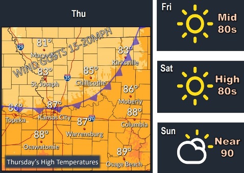
Cooler weather is in store for Wyandotte County today, with a high near 82, according to the National Weather Service.
The high will be in the mid to upper-80s for the rest of the week, the weather service said. No hazardous weather is expected.
A drier pattern will continue through the end of the week, according to the weather service.
Today, it will be sunny, with a high near 82 and a southwest wind of 7 to 13 mph becoming north in the afternoon, the weather service said.
Tonight, it will be clear, with a low of 56, according to the weather service. A north wind of 5 to 7 mph will become calm in the evening.
Friday, it will be sunny with a high near 84 and a calm wind becoming south around 6 mph in the afternoon, the weather service said.
Friday night, it will be clear with a low around 64, according to the weather service. A south wind around 6 mph will become calm in the evening.
Saturday, it will be sunny with a high near 90, and a south southwest wind of 5 to 9 mph, the weather service said.
Saturday night, it will be mostly clear, with a low of 72, according to the weather service.
Sunday, it will be mostly sunny, with a high near 92, the weather service.
Sunday night, it will be partly cloudy, with a low of 69, according to the weather service.
Monday, Labor Day, it will be mostly sunny, with a high near 89, the weather service said.
Monday night, there is a 30 percent chance of showers and thunderstorms, with a low of 65, according to the weather service.
Tuesday, there is a 50 percent chance of showers and thunderstorms, with a high near 75, the weather service said.
Tuesday night, there is a 40 percent chance of showers, with a low of 52, according to the weather service.
Wednesday, there is a 30 percent chance of showers, with a high near 68, the weather service said.