
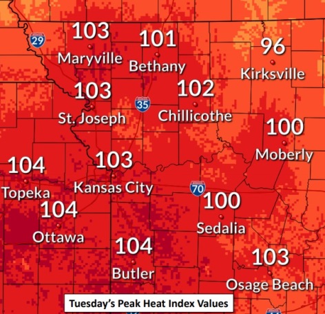
Wyandotte County is under a heat advisory this afternoon, with storms possible tonight, according to the National Weather Service.
The heat advisory is in effect from noon to 8 p.m. Tuesday, July 14. The heat index this afternoon could rise to about 102 in Wyandotte County, the weather service said.
Residents are advised to drink plenty of fluids, stay in an air-conditioned room, stay out of the sun and check up on relatives and neighbors, according to the weather service. Young children and pets should never be left unattended in vehicles under any circumstances, the weather service said.
Those who work outdoors or spend time outside should take extra precautions, according to the weather service. When possible, reschedule strenuous activities for early morning or evening.
People should wear lightweight and loose-fitting clothes when possible, the weather service said. Those who do outdoor work should schedule frequent rest breaks in shaded or air-conditioned environments. Anyone overcome by heat should be moved to a cool and shaded location. Heat stroke is an emergency and people may call 911.
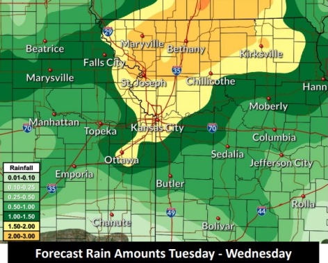
Severe storms are possible Tuesday evening into the overnight hours, according to the weather service. Large hail and damaging winds are the main hazards during the evening hours.
Hail and wind hazards transition to heavy rain and flooding hazard overnight across areas mainly north of I-70, the weather service said.
Dangerous heat also is possible later in the week, according to the weather service.
Today, there is a 40 percent chance of showers, mainly before 10 a.m., with a high of 94. The heat index may be as high as 102. A south southwest wind of 7 to 11 mph will gust as high as 21 mph.
Tonight, there is a 60 percent chance of showers and thunderstorms, mainly after 4 a.m., with a low of 72, according to the weather service. A south southeast wind of 5 to 8 mph will become east after midnight. Between 1 and 2 inches of rain are possible.
Wednesday, there is a 60 percent chance of showers and thunderstorms, mainly before 1 p.m., the weather service said. The high will be near 86 with an east wind of 3 to 7 mph. Between a quarter and half-inch of rain is possible.
Wednesday night, it will be partly cloudy, with a low of 70 and a light northeast wind, according to the weather service.
Thursday, there is a 20 percent chance of showers and thunderstorms after 1 p.m., with a high near 90, and a light east wind, the weather service said.
Thursday night, it will be partly cloudy, with a low of 75, according to the weather service.
Friday, it will be partly sunny, with a high near 96, the weather service said.
Friday night, it will be partly cloudy, with a low of 79, according to the weather service.
Saturday, it will be mostly sunny and hot, with a high near 98, the weather service said.
Saturday night, it will be mostly clear, with a low of 79, according to the weather service.
Sunday, it will be sunny and hot, with a high near 98, the weather service said.
Sunday night, it will be mostly clear, with a low of 77, according to the weather service.
Monday, it will be sunny with a high near 96, the weather service said.