Temperatures in the low 90s are in today’s forecast from the National Weather Service, along with a chance of storms tonight.
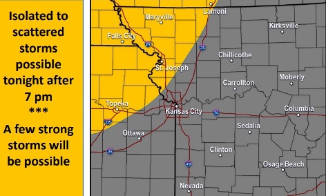
Storms may move south and east through the overnight hours, the weather service said. While severe weather is not expected, a strong storm or two is possible in the region.
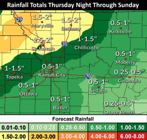
Gusty winds and heavy rain will be the primary threats, according to the weather service. Up to 2 inches of rain is possible in some areas. Some parts of the region may experience flooding. Rain will be heavier to the north of Wyandotte County.
Storms will continue on Friday and Saturday, with strong storms possible on Saturday, the weather service said.
With the cold front moving in later today, temperatures will be lower on the weekend, in the mid-80s on Friday and Saturday, rising to 89 on Sunday, according to the weather service.
Today, it will be sunny with a high near 92 and a south wind of 7 to 10 mph, the weather service said.
Tonight, there is a 50 percent chance of showers and thunderstorms, mainly after 10 p.m., according to the weather service. The low will be around 71 with a south wind of 3 to 6 mph. Less than a tenth of an inch of rain is possible.
Friday, there is a 70 percent chance of rain and storms, mainly after 1 p.m., with a high near 85, the weather service said. A calm wind will become southwest around 6 mph in the morning. Between a quarter and half-inch of rain is possible.
Friday night, there is an 80 percent chance of showers and thunderstorms, with a low of 69, according to the weather service. New rainfall amounts are between a quarter and half-inch of rain possible.
Saturday, there is an 80 percent chance of showers and thunderstorms, with a high near 85, the weather service said. A calm wind will become southwest 5 to 7 mph in the orning. Winds may gust as high as 20 mph. Between a tenth and quarter-inch of rain is possible.
Saturday night, there is a 40 percent chance of showers and thunderstorms, mainly before 1 a.m., according to the weather service. The low will be around 66. Less than a tenth of an inch of rain is expected.
Sunday, there is a 30 percent chance of showers and thunderstorms, with a high near 89, the weather service said.
Sunday night, there is a 50 percent chance of showers and thunderstorms, with a low of 69, according to the weather service.
Monday, there is a 40 percent chance of showers and thunderstorms, with a high near 88, the weather service said.
Monday night, there is a 30 percent chance of showers and thunderstorms, with a low of 67, according to the weather service.
Tuesday, it will be mostly sunny, with a high near 87, the weather service said.
Tuesday night, there is a 30 percent chance of showers and thunderstorms, with a low of 66, according to the weather service.
Wednesday, there is a 30 percent chance of showers and thunderstorms, with a high near 85, the weather service said.
For more weather information, visit www.weather.gov.