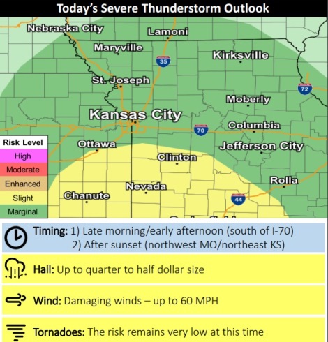
Following showers and storms early this morning, there will be a chance of more rain in the late morning and early afternoon with a broken line of storms along the Missouri-Kansas border.
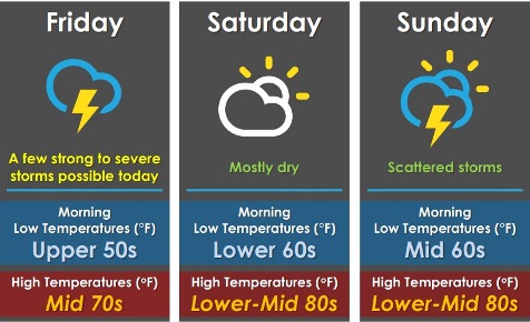
A few strong to severe storms are possible, mainly south of I-70, with up to half-dollar-sized hail and strong winds up to 60 mph possible, according to the National Weather Service.
Another round of storms is possible across the region tonight after sunset, the weather service said. A strong storm is possible with up to quarter-sized hail and wind up to 60 mph as the main concerns.
Saturday should be mostly dry, with multiple rounds of storms expected Sunday through Tuesday, according to the weather service.
Today, there is a 70 percent chance of showers and thunderstorms before 4 p.m., then a slight chance of showers and thunderstorms after 5 p.m., the weather service said. There will be a high near 75 with a southeast wind of 6 to 10 mph. Between a half and three-quarters of an inch of rain is possible.
Tonight, there is a 50 percent chance of showers and thunderstorms, mainly after 8 p.m., according to the weather service. The low will be around 61 with a south wind of 6 to 8 mph. Between a tenth and quarter-inch of rain is possible.
Saturday, there is a 30 percent chance of showers and thunderstorms before 8 a.m., with a high near 85, the weather service said. A calm wind will become south southwest 5 to 7 mph in the afternoon. Less than a tenth of an inch of rain is expected.
Saturday night, there is a 30 percent chance of showers and thunderstorms, mainly after 2 a.m., according to the weather service. The low will be around 70 with a south wind of 8 mph. Less than a tenth of an inch of rain is expected.
Sunday, there is a 70 percent chance of showers and thunderstorms likely, mainly after 2 p.m., with a high near 84, the weather service said. A south wind of 7 to 10 mph will gust as high as 22 mph. Less than a tenth of an inch of rain is expected.
Sunday night, there is an 80 percent chance of showers and thunderstorms, with a low of 68, according to the weather service. Between a tenth and quarter-inch is possible.
Monday, Memorial Day, there is an 80 percent chance of showers and thunderstorms before 8 a.m., then showers and possibly a thunderstorm after 8 a.m., the weather service said. The high will be near 78.
Monday night, there is an 80 percent chance of showers and possibly a thunderstorm before 8 p.m., then showers and thunderstorms are likely, mainly between 8 p.m. and 2 p.m., according to the weather service. The low will be around 64.
Tuesday, there is a 50 percent chance of showers and thunderstorms, with a high near 78, the weather service said.
Tuesday night, there is a 50 percent chance of showers and thunderstorms before 2 a.m., with a low of 65, according to the weather service.
Wednesday, there is a 40 percent chance of showers and thunderstorms, with a low of 65, the weather service said.
Wednesday night, there is a 40 percent chance of showers and thunderstorms, with a low of 65, according to the weather service.
Thursday, there is a 50 percent chance of showers and thunderstorms, with a high near 80, the weather service said.
For more weather information, visit www.weather.gov.