A wind chill advisory is in effect this morning until noon for Wyandotte County and the Kansas City area, according to the National Weather Service.
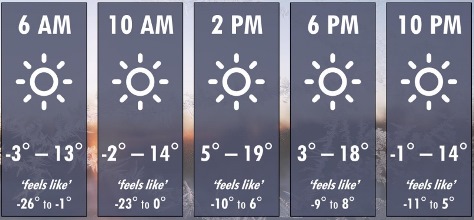
Minimum wind chill values this morning will range from minus 26 to minus 1, the weather service said.
According to the weather service, the cold wind chills could cause frostbite on exposed skin in as little as 30 minutes. Residents are advised to use caution while traveling outside, and wear appropriate clothing, including a hat and gloves, the weather service said.
After the strong cold front pushed through the region, the area is seeing strong northwest winds and dangerously cold wind chills, according to the weather service.
The quick drop in temperatures has resulted in flash freezing, creating slick road conditions this morning, according to the weather service.
Friday morning will be similar to this morning, but winds will be lighter, so wind chill values will range from minus 10 to 0 degrees, the weather service said.
The weather will warm up for the weekend, as Saturday and Sunday will have highs in the 40s and 50s, according to the weather service.
The next chance for rain will be Monday, the weather service said.
At 9 a.m. Thursday, Feb. 13, snow from Wednesday was still on the ground in Wyandotte County, and the temperature was 5 degrees, with a wind chill reading of minus 11.
Today’s high will be 16 degrees with sunny skies, the weather service said. There will be a north northwest wind between 3 and 9 mph.
Tonight, it will be clear with a low of 3 degrees, according to the weather service. A calm wind will become southeast between 6 and 9 mph.
Friday, it will be sunny, with highs around 30, the weather service said. A south southeast wind will be between 6 and 12 mph, with gusts as high as 19 mph.
Friday night, it will be partly cloudy, with lows mostly in the upper 20s, according to the weather service. A south wind between 7 and 10 mph will gust as high as 20 mph.
Saturday, it will be cloudy, then becoming mostly sunny, with highs mostly in the middle 40s, the weather service said. There will be a south wind of 6 mph.
Saturday night, it will be mostly cloudy, with lows mainly in the upper 20s, according to the weather service.
Sunday, it will be partly sunny, with highs mainly in the lower 50s, the weather service said.
Sunday night, it will be mostly cloudy, with lows mainly in the middle 30s, according to the weather service.
Monday, Presidents Day, there is a 30 percent chance of rain, with highs mainly in the upper 40s, the weather service said.
Monday night, there is a 30 percent chance of rain, with lows mainly in the middle 20s, according to the weather service.
Tuesday, there is a 30 percent chance of snow with highs mainly in the middle 30s, the weather service said.
Tuesday night, it will be partly cloudy, with lows mostly in the lower 20s, according to the weather service.
Wednesday, it will be mostly sunny, with highs mostly in the upper 30s, the weather service said.