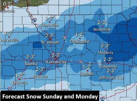
Although today’s temperatures will be in the 50s, light snow is in the forecast for Sunday and Monday, according to the National Weather Service.
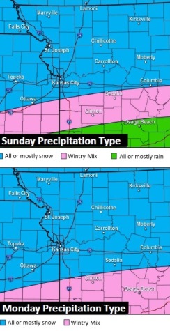
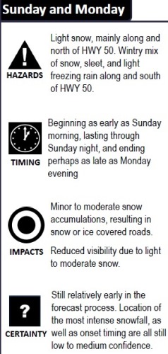
A wintry mix of snow, sleet and freezing rain is possible, the weather service said. Minor accumulations are possible.
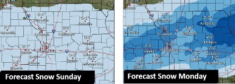
The snow will begin as early as Sunday morning, last through Sunday night, and end as late as Monday evening, according to the weather service.
Reduced visibility for drivers will be possible, the weather service said.
It is still early in the forecast process, so the location and timing of the snow are not quite certain, according to the weather service. Those who are traveling should be aware that the timing and location of the snow could change.
Before Sunday’s precipitation, there is a 20 percent chance for drizzle, snow and freezing drizzle late tonight and overnight, the weather service said. A cold front will move through tonight.
The area will not see a return to the 50s for at least another week.
Today, it will be partly sunny, with a high near 54, the weather service said, and a south southwest wind of 3 to 6 mph.
Tonight, there will be a 20 percent chance of drizzle before 2 a.m., then a slight chance of snow and freezing drizzle between 2 a.m. and 3 a.m., with a low of 27, according to the weather service. A southwest wind of 5 to 13 mph will become north northwest after midnight. Winds may gust up to 18 mph.
Saturday, it will be partly sunny, with a high near 33 and a north northwest wind of 6 to 11 mph, the weather service said.
Saturday night, it will be mostly cloudy, with a low of 20 and a light north wind, according to the weather service.
Sunday, there is a 40 percent chance of snow before 3 p.m., then a chance of snow and freezing rain. It will be mostly cloudy, with a high near 31 and a calm wind becoming east around 5 mph in the afternoon. Less than an inch of precipitation is in the forecast.
Sunday night, there is a 50 percent chance of snow and freezing rain before 3 a.m., then a chance of snow between 3 a.m. and 5 a.m., then a chance of snow and freezing rain after 5 a.m., according to the weather service. The low will be around 23. Between a tenth and quarter-inch of precipitation is possible.
Monday, there is a 50 percent chance of snow, with a high near 30, the weather service said.
Monday night, it will be partly cloudy, with a low of 17, according to the weather service.
Tuesday, it will be sunny, with a high near 34, the weather service said.
Tuesday night, it will be mostly clear, with a low of 14, according to the weather service.
Wednesday, it will be sunny, with a high near 40, the weather service said.
Wednesday night, it will be mostly clear, with a low of 25, according to the weather service.
Thursday, it will be mostly sunny, with a high near 43, the weather service said.