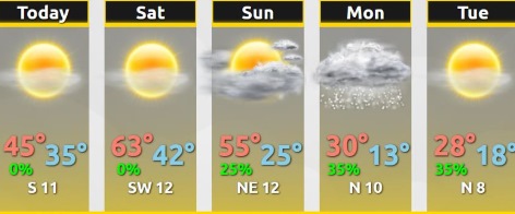
Warm temperatures are expected for the weekend, before a strong cold front arrives Sunday evening, according to the National Weather Service.
Minor snow accumulations are expected Sunday night into Monday morning, mainly north of I-70, the weather service said.
Frigid temperatures will follow in the wake of the cold front, with the coldest period from Monday to Tuesday.
Today, expect sunny skies with a high near 46 and a south wind of 8 to 10 mph, the weather service said.
Friday night, it will be mostly clear, with a low of 34, according to the weather service, and a southwest wind of 9 to 11 mph.
Saturday, it will be sunny with a high near 64 and a southwest wind of 6 to 9 mph, the weather service said.
Saturday night, it will be mostly clear, with a low of 44 and a south southwest wind around 6 mph becoming calm after midnight, according to the weather service.
Sunday, it will be mostly sunny, with a high near 51 and a calm wind becoming north northeast 5 to 8 mph in the morning, the weather service said.
Sunday night, there is a 30 percent chance of snow after midnight, with a low of 26, according to the weather service.
Monday, Veterans Day, there is 30 percent chance of snow before noon, with a high near 29, the weather service said.
Monday night, it will be mostly clear with a low of 14, according to the weather service.
Tuesday, it will be sunny with a high near 29, the weather service said.
Tuesday night, it will be mostly clear, with a low of 19, according to the weather service.
Wednesday, it will be mostly sunny, with a high near 42, the weather service said.
Wednesday night, it will be partly cloudy, with a low of 28, according to the weather service.
Thursday, it will be mostly sunny, with a high near 43, the weather service said.