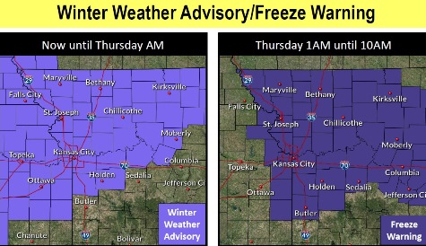
A winter weather advisory continues for Wyandotte County from now through 4 a.m. Thursday, according to the National Weather Service.
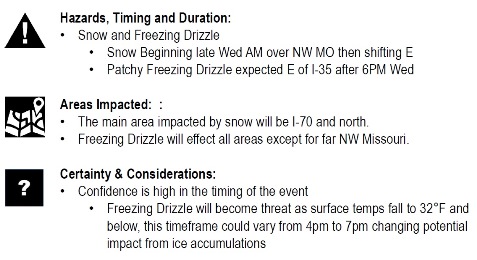
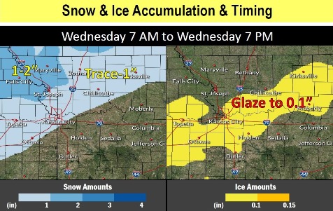
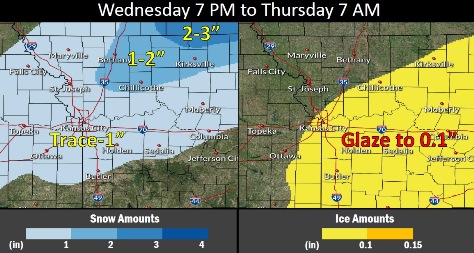
Mixed precipitation, including snow and freezing drizzle, are possible. Snow accumulations of about an inch are possible in Wyandotte County, with ice or freezing drizzle also possible, the weather service said.
Motorists should plan on slippery road conditions, according to the weather service.
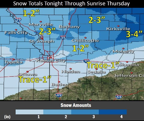
The heaviest snowfall is expected to be north of the Kansas City area, with Wyandotte County receiving a trace of snow. Freezing drizzle may cause slick roads here, the weather service said.
A freeze warning has been issued from 1 a.m. to 10 a.m. Thursday. Frost and freeze conditions could kill crops, other sensitive vegetation and possibly damage unprotected outdoor plumbing, according to the weather service.
The temperature at 9 a.m. Wednesday was 36 degrees, with a wind chill of 29.
Today, there is a 90 percent chance of rain showers likely before 10 a.m., then rain, possibly mixed with snow showers, the weather service said. The high will be near 35 with a north wind of 7 to 15 mph, gusting as high as 22 mph. Less than a half-inch of total daytime snow accumulation is in the forecast.
Tonight, there is an 80 percent chance of drizzle, snow showers and freezing drizzle before 1 a.m., then a slight chance of snow showers between 1 a.m. and 4 a.m., according to the weather service. The low will be around 23 with a northwest wind of 8 to 14 mph, gusting as high as 20 mph. Little or no ice accumulation is expected. New snow accumulation could be less than one inch.
Thursday, it will be sunny with a high near 38 and a west wind of 8 to 10 mph, the weather service said.
Thursday night, it will be clear with a low of 25 and a light south southwest wind, according to the weather service.
Friday, it will be sunny with a high near 45 and a south southwest wind around 6 mph, the weather service said.
Friday night, it will be partly cloudy, with a low of 29, according to the weather service.
Saturday, it will be sunny with a high near 45, the weather service said.
Saturday night, it will be mostly clear, with a low of 31, according to the weather service.
Sunday, it will be sunny, with a high near 53, the weather service said.
Sunday night, it will be mostly clear, with a low of 38, according to the weather service.
Monday, it will be mostly sunny with a high near 56, the weather service said.
Monday night, it will be mostly cloudy, with a low of 37, according to the weather service.
Tuesday, it will be mostly sunny, with a high near 51, the weather service said.
For more weather information, visit www.weather.gov.