The weather forecast contains thunderstorms, rain, gusty winds, possible freezing temperatures and minor flooding.
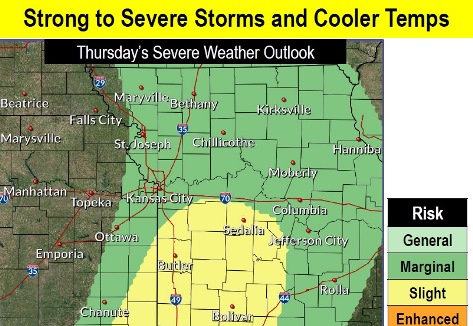
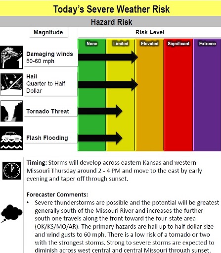
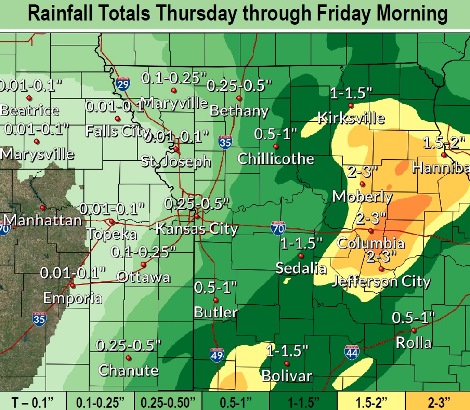
This afternoon and evening, strong to severe thunderstorms may move into the area, bringing rainfall of up to a half-inch in Wyandotte County through Friday morning, according to the National Weather Service.
Storms and showers could move into the area before noon, then more showers are likely between noon and 1 p.m. followed by showers and possibly a thunderstorm after 1 p.m. in Wyandotte County, the weather service said. The cold front is moving into the region from 2 to 4 p.m. Thursday, according to the weather service.
Gusty winds, possibly as high as 26 mph, are possible today, according to the weather service. There is also a risk of hail and flash flooding, along with a low risk of tornados in some parts of the region.
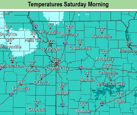
The first freeze of the season could occur Friday night or Saturday morning, as the temperature could drop to around 32 on Friday night, the weather service said. Thursday’s daytime high will be 71 compared to Friday’s daytime high of 48.
Wind chills could drop into the 20s on Saturday morning, according to the weather service.
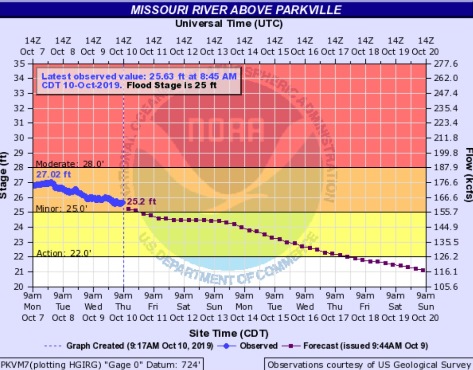
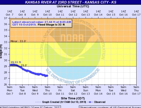
A flood warning continues at the Missouri River at Parkville, where the gauge is on I-435 between Wyandotte and Platte counties, the weather service said. The river at this point is in minor flood stage, and is expected to fall into action stage on Thursday or Friday. The Kansas River at 23rd Street, where the gauge is near Kansas Avenue and the state line, is currently below action stage and below minor flood stage.
Today, there is a 70 percent chance of showers and thunderstorms before noon, then showers likely between noon and 1 p.m., then showers likely and possibly a thunderstorm after 1 p.m., the weather service said. The high will be near 71 with a south southeast wind of 8 to 14 mph becoming southwest in the afternoon. Winds may gust as high as 26 mph. Between a tenth and quarter-inch of rain is possible.
Tonight, there is a 30 percent chance of showers and thunderstorms before 4 a.m., then a slight chance of showers, according to the weather service. Cloudy skies will gradually clear. The low will be 37. A northwest wind of 15 mph will gust as high as 26 mph. Less than a tenth of an inch of rain is possible.
Friday, there is a 20 percent chance of showers before 1 p.m., the weather service said. The high will be near 48 with a west northwest wind of 13 to 17 mph, gusting as high as 25 mph.
Friday night, there is a chance of frost before midnight, then widespread frost after 1 a.m., according to the weather service. The low will be around 32 with a west wind of 3 to 6 mph.
Saturday, widespread frost is possible before 8 a.m. the weather service said. The high will be near 60 with a west wind of 5 to 10 mph, gusting as high as 25 mph.
Saturday night, it will be clear with a low of 40, according to the weather service.
Sunday, it will be sunny, with a high near 62, the weather service said.
Sunday night, it will be mostly clear, with a low of 42, according to the weather service.
Monday, Columbus Day, it will be mostly sunny, with a high near 69, the weather service said.
Monday night, it will be partly cloudy, with a low of 48, according to the weather service.
Tuesday, it will be mostly sunny, with a high near 63, the weather service said.
Tuesday night, it will be mostly clear, with a low of 39, according to the weather service.
Wednesday, it will be sunny, with a high near 59, the weather service said.