Today will be sunny and mild, with a high near 71, according to the National Weather Service.
A strong cold front will move into the area late Wednesday through Friday, the weather service said.
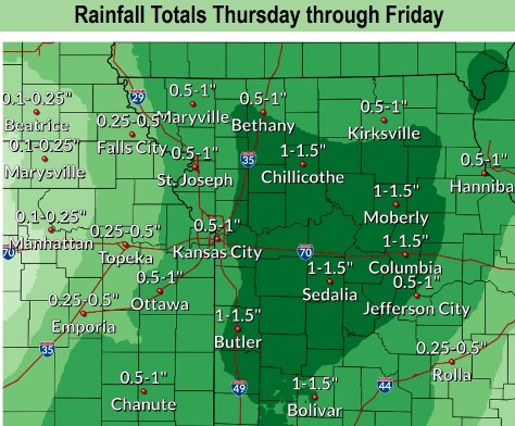
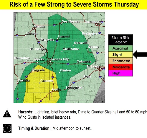
Thunderstorms, gusty winds and cooler temperatures may follow. A few strong storms are possible in the region. Rainfall totals Thursday through Friday could be a half-inch to 1.5 inches in the region, according to the weather service.
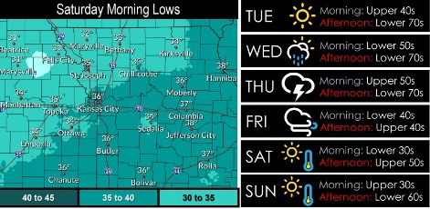
Parts of the region may experience their first near-freezing or at-freezing temperatures of the season on Saturday morning, the weather service said.
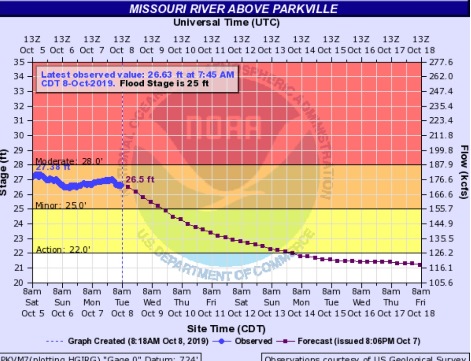
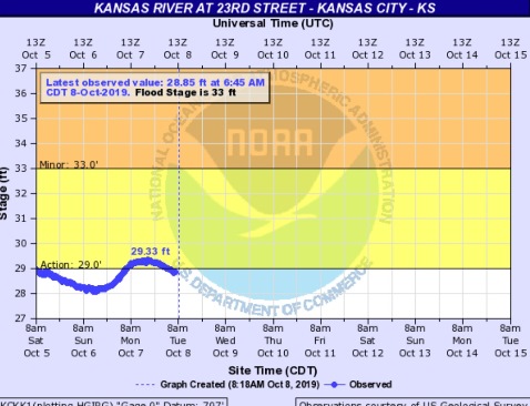
The Missouri River at Parkville, where the gauge is on I-435 over the Missouri River between Wyandotte and Platte counties, currently is in minor flood stage. The Kansas River at 23rd Street, where the gauge is near Kansas Avenue and the state line, is below minor flood stage and this morning, it went below the action stage.
Today, the high will be near 71 with a calm wind becoming south 5 to 8 mph in the afternoon, the weather service said.
Tonight, it will be mostly clear, with a low of 52 and a south southeast wind of 3 to 5 mph, according to the weather service.
Wednesday, there is a 20 percent chance of showers after 1 p.m., then gradually becoming mostly sunny, with a high near 69, the weather service said. A south wind of 6 to 9 mph may gust as high as 25 mph.
Wednesday night, there is a 60 percent chance of showers and thunderstorms, then showers are likely and possibly a thunderstorm after 1 a.m., according to the weather service. It will be mostly cloudy with a low of 59. A south southeast wind will be around 8 mph, gusting to as high as 21 mph. Less than a tenth of an inch of rain is possible.
Thursday, there is a 60 percent chance of showers and thunderstorms, then showers are likely after 1 a.m., the weather service said. The high will be near 75 with a south wind of 9 to 13 mph, gusting to as high as 25 mph. Between a quarter and half-inch of rain is in the forecast.
Thursday night, there is a 60 percent chance of showers and thunderstorms, then showers likely after 1 a.m., according to the weather service. The low will be around 44. Between a quarter and half-inch of rain are possible.
Friday, there is a 30 percent chance of showers before 1 p.m., with a high near 49, the weather service said.
Friday night, it will be mostly clear, with a low of 36, according to the weather service.
Saturday, it will be sunny with a high near 58, the weather service said.
Saturday night, it will be mostly clear, with a low of 39, according to the weather service.
Sunday, it will be sunny with a high near 62, the weather service said.
Sunday night, it will be mostly clear with a low of 41, according to the weather service.
Monday, Columbus Day, it will be mostly sunny with a high near 66, the weather service said.