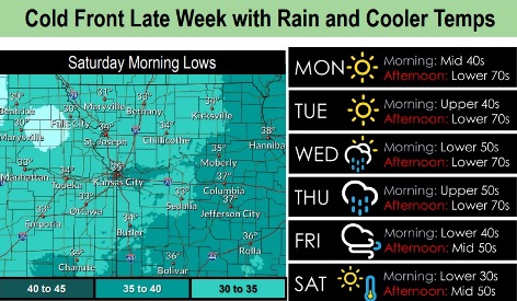
The weather will be seasonable through mid-week, with a strong cold front moving in on late Wednesday, according to the National Weather Service.
Rain and cooler temperatures are in the forecast for Wednesday through Friday, the weather service said.
Parts of the region may experience their first near-freezing temperatures or at-freezing temperatures on Saturday morning, although there is some uncertainty about the frost forecast, according to the weather service.
Today and Tuesday, the weather will be mild.
Patchy fog will be possible again on Tuesday morning in areas near river valleys, the weather service said.
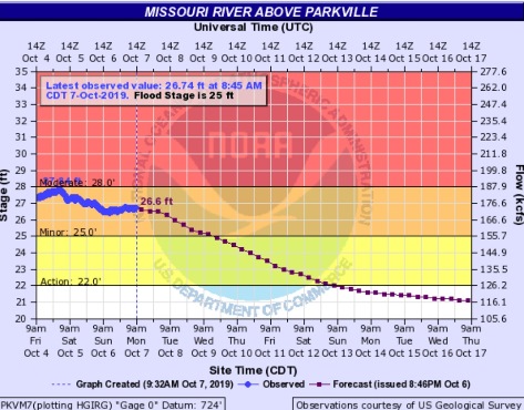
A flood warning continues for portions of the Missouri River. The Missouri River at Parkville, where the gauge is on I-435 between Wyandotte County and Platte County, currently is in minor flood stage, according to hydrology charts.
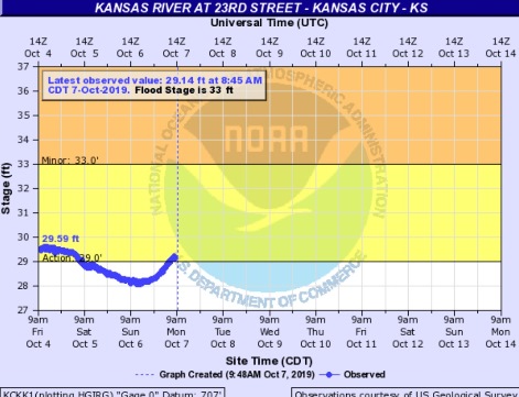
The Kansas River at 23rd Street, where the gauge is at Kansas Avenue near the state line, currently is in action stage, which is below minor flood stage, according to hydrology charts.
Today, it will be sunny with a high near 70 and a calm wind, the weather service said.
Tonight, it will be clear with a low of 46 and a calm wind, according to the weather service.
Tuesday, it will be sunny with a high near 71 and a calm wind becoming south 5 to 9 mph in the morning, the weather service said.
Tuesday night, it will be mostly clear, with a low of 52 and a south southeast wind of 3 to 5 mph, according to the weather service.
Wednesday, there is a 20 percent chance of showers and thunderstorms after 1 p.m., with a high near 71, the weather service said. A south wind of 6 to 10 mph may gust as high as 21 mph.
Wednesday night, there is a 70 percent chance of showers and thunderstorms, then showers are likely and possibly a thunderstorm after 1 a.m., according to the weather service. It will be partly cloudy, with a low of 59. Between a tenth and quarter-inch of rain is expected.
Thursday, there is a 60 percent chance of showers and possibly a thunderstorm before 1 p.m., then a chance of showers and thunderstorms after 1 p.m., the weather service said. The high will be near 74.
Thursday night, there is a 50 percent chance of showers and thunderstorms, with a low of 44, according to the weather service.
Friday, there is a 50 percent chance of showers with a high near 53, the weather service said.
Friday night, it will be partly cloudy, with a high of 57, according to the weather service.
Saturday, it will be sunny with a high near 57, the weather service said.
Saturday night, it will be clear, with a low near 39, according to the weather service.
Sunday, it will be sunny, with a high near 62, the weather service said.