Fall temperatures have arrived today, as a cool front has moved into the area.
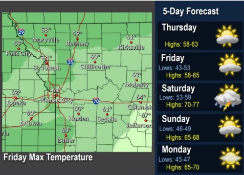
Today’s weather, after the morning hours, should be drier, with a high near 60, according to the National Weather Service.
Temperatures are in the lower 50s to start the day, and lingering light rain will taper off during the early morning as the cold front pushes south, the weather service said.
Clouds will persist through most of the day. Afternoon highs will peak in the upper 50s to lower 60s, around 10 degrees below normal, according to the weather service.
A few showers may be possible late this morning.
Cool temperatures are expected to remain through Friday, until warmer temperatures return Saturday.
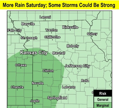
Saturday also has the potential for another round of showers and isolated thunderstorms ahead of a cold front, according to the weather service.
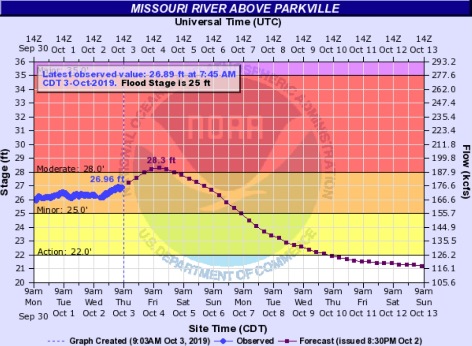
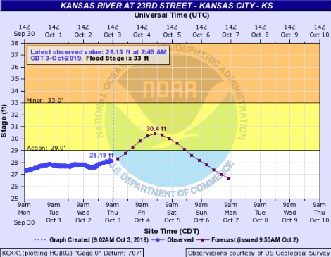
A flood warning continues for the Missouri River. The Missouri River at Parkville, where the gauge is on I-435 over the Missouri River between Wyandotte County and Platte County, is in minor flood stage currently and is forecast to rise to moderate flood stage. The Kansas River at 23rd Street, where the gauge is at Kansas Avenue and the state line, is below flood stage and is expected to go into action stage, according to hydrology charts.
Today, it will be mostly cloudy with a high near 60 and a north wind of 6 to 9 mph, the weather service said.
Tonight, it will be partly cloudy, with a low of 60 and a north wind of 6 to 8 mph, according to the weather service.
Friday, it will be mostly sunny, with a high near 62 and an east wind of 7 to 9 mph, the weather service said.
Friday night, it will be mostly cloudy with a low of 58 and an east wind of 3 to 6 mph, according to the weather service.
Saturday, there is a 70 percent chance of showers and thunderstorms, mainly between 8 a.m. and 2 p.m., the weather service said. The high will be near 75 with a south wind of 7 to 10 mph becoming west northwest in the afternoon. Winds may gust as high as 26 mph. Between a quarter and half-inch of rain is possible.
Saturday night, there is a 50 percent chance of showers and thunderstorms before 8 p.m., according to the weather service. The low will be around 48. Less than a tenth of an inch of rain is expected.
Sunday, it will be mostly sunny with a high near 67, the weather service said.
Sunday night, it will be mostly clear, with a low of 47, according to the weather service.
Monday, it will be sunny with a high near 69, the weather service said.
Monday night, it will be mostly clear, with a low of 47, according to the weather service.
Tuesday, it will be sunny, with a high near 69, the weather service said.
Tuesday night, it will be mostly clear, with a low of 51, according to the weather service.
Wednesday, it will be mostly sunny, with a high near 72, the weather service said.