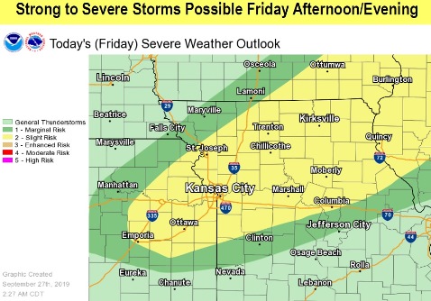
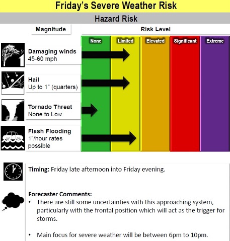
There is a slight risk of severe weather late Friday afternoon and evening, according to the National Weather Service forecast.
The storm could include damaging winds, large hail and flash flooding, the weather service said.
Less severe storms also are possible Friday morning, as a cold front moves through, according to the weather service.
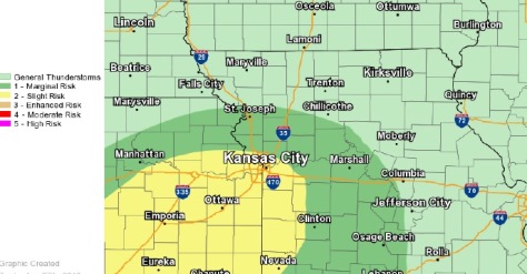
There also is a slight risk of severe weather Saturday afternoon and evening, according to the weather service, with damaging winds and isolated flash flooding possible.
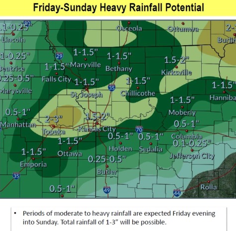
From 1.5 to 2 inches of rain are likely on Friday and Saturday, the weather service said.
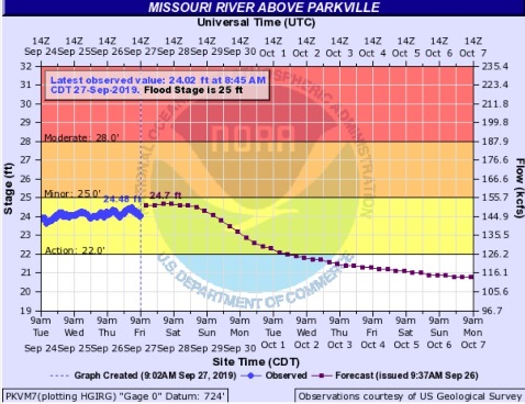
Flooding along the Missouri River could become enhanced by the additional rainfall, the weather service said.
The Missouri River at Parkville, where the gauge is on I-435 between Wyandotte County and Platte County, is currently in action stage and below flood stage.
Today, there will be a 30 percent chance of showers and thunderstorms mainly after 5 p.m., the weather service said. The high will be near 87 with a south southwest wind of 17 to 20 mph, gusting as high as 41 mph. Less than a tenth of an inch of rain is possible.
Tonight, there is a 90 percent chance of showers and possibly a thunderstorm before 7 p.m., then showers and thunderstorms between 7 p.m. and 1 a.m., then showers and possibly a thunderstorm after 1 a.m., according to the weather service. The low will be around 63 with a northwest wind of 8 to 11 mph becoming northeast after midnight. Between three-quarters and one inch of rain is possible.
Saturday, there is a 50 percent chance of showers and thunderstorms, with a high near 75 and an east northeast wind of 8 to 10 mph, the weather service said. Between a quarter and half-inch of rain are possible.
Saturday night, there is a 50 percent chance of showers and thunderstorms with a low of 69, according to the weather service. An east wind of 5 to 9 mph will become light and variable. Between a quarter and half-inch of rain is possible.
Sunday, there is a 30 percent chance of showers and thunderstorms before 1 p.m., then a slight chance of showers, the weather service said. The high will be near 84 with a south wind of 6 to 11 mph, gusting as high as 25 mph. Less than a tenth of an inch of rain is possible.
Sunday night, it will be partly cloudy with a low of 72, according to the weather service.
Monday, it will be mostly sunny with a high near 86, the weather service said.
Monday night, it will be mostly cloudy, with a low of 72, according to the weather service.
Tuesday, there is a 30 percent chance of showers, with thunderstorms also possible after 1 p.m., the weather service said. The high will be near 85.
Tuesday night, there is a 40 percent chance of showers and thunderstorms, with a low of 68, according to the weather service.
Wednesday, there is a 60 percent chance of showers and thunderstorms, with a high near 75, the weather service said.
Wednesday night, there is a 40 percent chance of showers and thunderstorms, with a low of 54, according to the weather service.
Thursday, it will be mostly cloudy, with a high near 67, the weather service said.