Thunderstorms are possible late Thursday or early Friday, according to the National Weather Service.
Temperatures will reach a high of 87 today in Wyandotte County, before showers and storms deliver between 1 and 2 inches of rain, the weather service said.
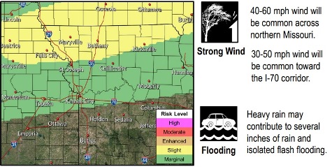
The storms on Thursday evening could be strong to severe, including strong winds, flash flooding, frequent lightning and heavy rain, according to the weather service.
Humidity will increase today as the temperatures climb, before the cold front moves in tonight, the weather service said. Storms will move southward from Iowa into Kansas and Missouri.
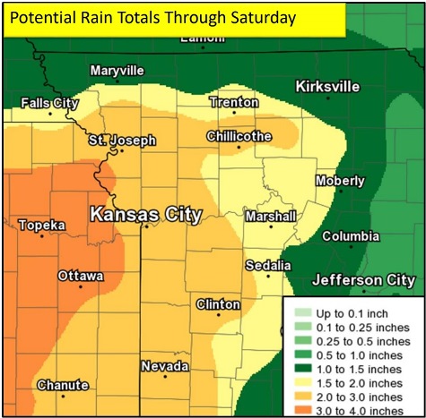
Off-and-on rain and storm chances will continue into Friday and Saturday as the frontal boundary stalls over central Missouri, according to the weather service. Rain chances will slowly come to an end by the late weekend, while surface temperatures will increase into the mid-80s by Tuesday, the weather service said.
The Missouri and Kansas rivers in Wyandotte County are currently below flood stage and below action stage.
Today, it will be mostly sunny, with a high near 87 and a south southwest wind of 10 to 13 mph, gusting as high as 24 mph, the weather service said.
Tonight, there is a 70 percent chance of showers and thunderstorms, mainly after 1 a.m., according to the weather service. The low will be around 68 with a south southwest wind of 6 to 8 mph, becoming north after midnight. Between 1 and 2 inches of rain are possible.
Friday, there is a 50 percent chance of showers and thunderstorms, mainly before 1 p.m., the weather service said. The high will be near 79 with an east wind of 5 to 8 mph. Between a tenth and quarter-inch of rain is possible.
Friday night, there is a 50 percent chance of showers and thunderstorms, with a low of 68 and an east wind of 5 mph becoming calm in the evening, according to the weather service. Between a half and three-quarters of an inch of rain are possible.
Saturday, there is a 70 percent chance of showers and thunderstorms, mainly before 1 p.m., the weather service said. The high will be near 75 with a light southeast wind. Between 1 and 2 inches of rain are possible.
Saturday night, there is a 30 percent chance of showers and thunderstorms, mainly before 1 a.m., according to the weather service. The low will be around 65 with less than a tenth of an inch of rain likely.
Sunday, it will be partly sunny with a high near 78, the weather service said.
Sunday night, it will be partly cloudy, with a low of 65, according to the weather service.
Monday, Labor Day, it will be mostly sunny with a high near 82, the weather service said.
Monday night, it will be clear with a low of 67, according to the weather service.
Tuesday, it will be sunny with a high near 87, the weather service said.
Tuesday night, it will be mostly clear with a low of 67, according to the weather service.
Wednesday, it will be sunny with a high near 83, the weather service said.