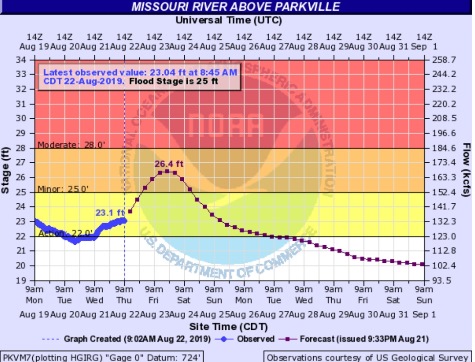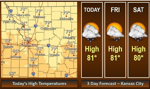
Today’s weather will be cooler, with a high near 81 and a 30 percent chance of rain, according to the National Weather Service. Also, there is a flood warning in effect for Thursday evening to Sunday afternoon for the Missouri River at Parkville.
Afternoon temperatures through the weekend will be about five to 10 degrees below normal, the weather service said.
A few scattered showers and rumbles of thunder will be possible through the end of the week, but no hazardous weather is expected, according to the weather service.
The flood warning will be in effect from Thursday evening to Sunday afternoon for the Missouri River at Parkville, which includes the Wyandotte County area. The gauge for this location is on I-435 over the Missouri River, between Wyandotte County and Platte County. Northwest Wyandotte County and the Wolcott area could be affected.
Minor flooding is forecast for the Missouri River. It may rise above flood stage by Thursday before midnight and continue to rise to near 26.4 feet by Friday evening, the weather service said. It could fall below flood stage by early Saturday afternoon.
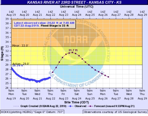
The Kansas River may rise into action stage on Friday. It is not currently projected to go into minor flood stage. The gauge for the Kansas River at 23rd is on Kansas Avenue at the state line.
Today, there is a 30 percent chance of showers and thunderstorms, with a high near 81 and a light east wind, the weather service said. Less than a tenth of an inch of rain is possible.
Tonight, there is a 50 percent chance of showers and thunderstorms, with a low of 66 and a light east wind, according to the weather service. Between a quarter and half-inch of rain is possible.
Friday, there is a 40 percent chance of showers and thunderstorms, mainly before 1 p.m., the weather service said. The high will be near 81 with an east wind of 3 to 7 mph. Between a quarter and half-inch of rain is possible.
Friday night, there is a 20 percent chance of showers and thunderstorms after 1 a.m., with a low of 66, and an east wind of 3 to 6 mph, according to the weather service.
Saturday, there is a 30 percent chance of precipitation with a high near 80 and a southeast wind of 6 mph, the weather service said. Between a quarter and half-inch of rain is possible.
Saturday night, there is a 30 percent chance of showers and thunderstorms, mainly after 1 a.m., with a low of 67, according to the weather service. Less than a tenth of an inch of rain is possible.
Sunday, there is a 40 percent chance of showers and thunderstorms, with a high near 82, the weather service said.
Sunday night, there is a 40 percent chance of showers and thunderstorms, with a low of 69, according to the weather service.
Monday, there is a 40 percent chance of showers and thunderstorms, with a high near 84, the weather service said.
Monday night, there is a 50 percent chance of showers and thunderstorms, with a low of 65, according to the weather service. Some of the storms could produce heavy rain.
Tuesday, there is a 30 percent chance of showers and thunderstorms, with a high near 81, the weather service said.
Tuesday night, there is a 40 percent chance of showers and thunderstorms, with a low of 63, according to the weather service. Some of the storms could produce heavy rain.
Wednesday, there is a 30 percent chance of showers and thunderstorms, with a high near 80, the weather service said.
For more weather information, visit www.weather.gov.