A heat advisory will be in effect today in Wyandotte County from 1 p.m. until 8 p.m., according to the National Weather Service.
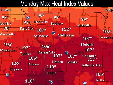
The heat index here may reach as high as 106, with temperatures near 94, the weather service said.
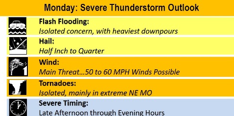
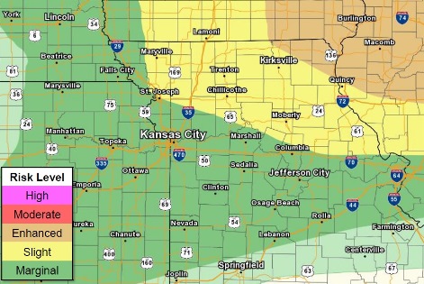
Scattered thunderstorms are possible this morning and after 5 p.m., according to the weather service.
Strong winds, heavy rain and isolated flash flooding are possible, the weather service said.
Damaging winds are the main hazard with the storms on late Monday afternoon and overnight, and an isolated tornado cannot be ruled out, particularly to the north.
With the heat advisory today, a combination of hot temperatures and high humidity could quickly cause heat stress or heat stroke if precautions are not taken, according to the weather service.
The very young, the elderly, those without air conditioning and those participating in strenuous outdoor activities will be the most susceptible, the weather service said. Also car interiors can reach lethal temperatures in a matter of minutes.
Move anyone overcome by heat to a shaded location. In the event of heat stroke, call 911.
Residents are advised to drink plenty of fluids, stay in an air-conditioned room, stay out of the sun, and check up on relatives and neighbors, the weather service said.
The Missouri and Kansas rivers in Wyandotte County are currently below flood stage and below action stage.
Today, there is a 20 percent chance of showers and thunderstorms before 10 a.m., then a slight chance of showers and thunderstorms after 5 p.m., the weather service said. It will be sunny, with a high near 94 and a heat index up to 106. An east southeast wind of 9 to 13 mph will become west southwest in the afternoon.
Tonight, there is a 30 percent chance of showers and thunderstorms, mainly before 1 a.m., according to the weather service. The low will be around 71 with a west wind of 6 to 9 mph becoming north northwest after midnight. Less than a tenth of an inch of rain is expected.
Tuesday, it will be partly sunny, then gradually becoming sunny, with a high near 87, and a north northwest wind of 6 to 9 mph, the weather service said.
Tuesday night, it will be mostly clear, with a low of 66 and a light north northwest wind, according to the weather service.
Wednesday, it will be mostly sunny with a high near 84 and a calm wind becoming north around 5 mph, the weather service said.
Wednesday night, it will be partly cloudy with a low of 64, according to the weather service.
Thursday, it will be mostly sunny with a high near 84, the weather service said.
Thursday night, it will be partly cloudy with a low of 69, according to the weather service.
Friday, it will be mostly sunny, with a high near 89, the weather service said.
Friday night, it will be partly cloudy with a low of 72, according to the weather service.
Saturday, it will be mostly sunny, with a high near 90, the weather service said.
Saturday night, there is a 30 percent chance of showers and thunderstorms, with a low of 73, according to the weather service.
Sunday, it will be sunny with a high near 90, the weather service said.