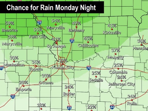
Rain and storms are in the forecast for Monday night through Friday, according to the National Weather Service forecast.
Tonight, there is a 40 percent chance of showers and thunderstorms after 10 p.m., and Tuesday, the chance of rain and storms is 30 percent, the weather service said.
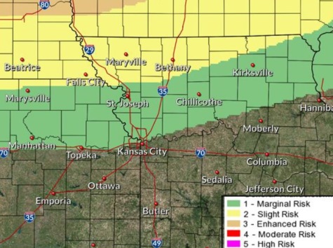
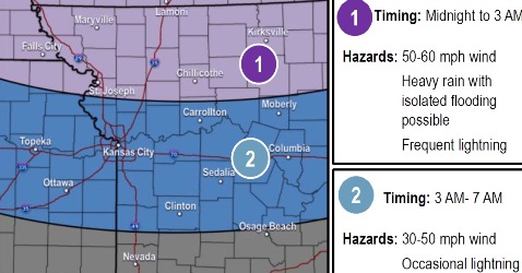
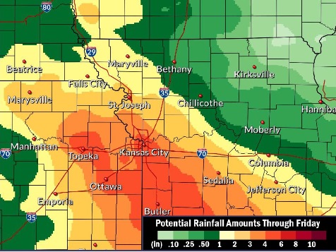
A cold front is moving into the area tonight from the north, according to the weather service. The worst storms could be north of the St. Joseph, Missouri, area, near the Iowa-Missouri line. Gusty winds of 50 to 60 mph are possible, with periods of heavy rain and frequent lightning, according to the weather service.
Thunderstorm chances will continue through the upcoming week with heavy rains possible, the weather service said.
Both the Missouri and Kansas rivers in Wyandotte County are below flood stage and below action stage on Monday morning, according to hydrology charts.
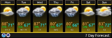
Today, it will be mostly sunny, with a high near 89 and a calm wind becoming south southwest 5 to 7 mph in the morning, the weather service said.
Tonight, there is a 40 percent chance of showers and thunderstorms after 10 p.m., according to the weather service. The low will be around 72 with a south southwest wind of 5 to 8 mph becoming north northwest after midnight. Between a quarter and half-inch of rain is possible.
Tuesday, there is a 30 percent chance of showers and thunderstorms before 1 p.m., with a high near 90, the weather service said. The heat index could be as high as 96. A north northeast wind will be 5 to 8 mph. Less than a tenth of an inch of rain is expected.
Tuesday night, there is a 20 percent chance of showers and thunderstorms after 1 a.m., with a low of 68, according to the weather service. The low will be around 68 with a north wind of 5 to 8 mph becoming calm in the evening.
Wednesday, there is a 20 percent chance of showers and thunderstorms, with a high near 90 and a calm wind, the weather service said.
Wednesday night, there is a 40 percent chance of showers and thunderstorms, mainly after 1 a.m., with a low of 71, according to the weather service. Between a quarter and half-inch of rain is possible.
Thursday, there is a 40 percent chance of showers and thunderstorms, with a high near 84, the weather service said.
Thursday night, there is a 50 percent chance of showers and thunderstorms, with a low of 67, according to the weather service. Some of the storms could produce heavy rain.
Friday, there is a 30 percent chance of showers and thunderstorms before 1 p.m., with a high of 72, the weather service said.
Friday night, it will be partly cloudy, with a low of 67, according to the weather service.
Saturday, it will be mostly sunny, with a high near 84, the weather service said.
Saturday night, it will be partly cloudy, with a low of 68, according to the weather service.
Sunday, it will be partly sunny, with a high near 86, the weather service said.