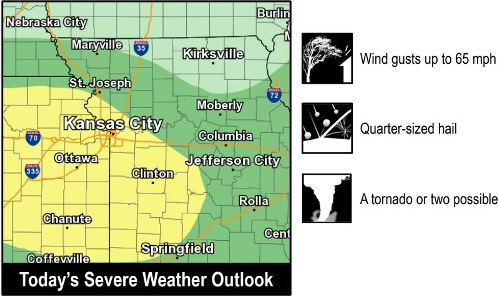
Severe storms will be possible this evening, including large hail, damaging winds and perhaps an isolated tornado in the region, according to the National Weather Service.
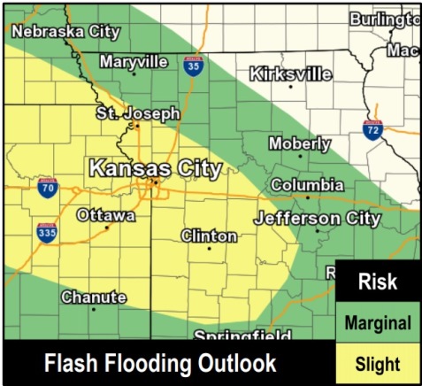
Also, heavy rain is possible with these storms that could cause flash flooding in areas, according to the weather service.
The excessive heat warning went off for Wyandotte County. The temperature at noon was 81 degrees, with a heat index of 85. Today’s high could be 90, with a heat index of 97, the weather service said.
The showers and thunderstorms, if they happen, may reach the Wyandotte County area after 5 p.m., according to the forecast. The chance of precipitation is 10 percent.
Tonight, there is a 90 percent chance of showers and thunderstorms, mainly before 3 a.m., according to the weather service. Some of the storms could produce heavy rainfall. The low will be around 70 with a north northeast wind of 7 to 10 mph. Between 1 and 2 inches of rain are possible.
Monday, there is a 30 percent chance of showers and storms before 7 a.m., with a high near 80, the weather service said. A north northeast wind of 11 to 14 mph may gust as high as 22 mph. Less than a tenth of an inch of rain is expected.
Monday night, it will be mostly clear, with a low of 61, according to the weather service. A north northeast wind of 5 to 9 mph will become calm in the evening.
Tuesday, it will be sunny with a high near 80 and a calm wind, the weather service said.
Tuesday night, it will be mostly clear, with a low of 60, according to the weather service.
Wednesday, it will be sunny, with a high near 82, the weather service said.
For more weather information, visit www.weather.gov.