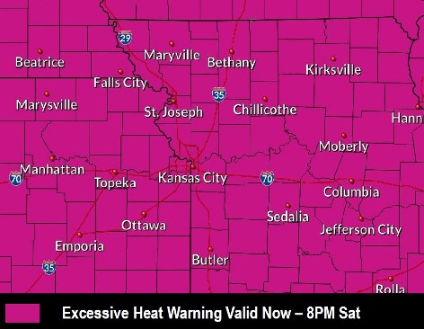
An excessive heat warning continues Friday for Wyandotte County, according to the National Weather Service.
The excessive heat warning is in effect from now through 8 p.m. Saturday, July 20, the weather service said.
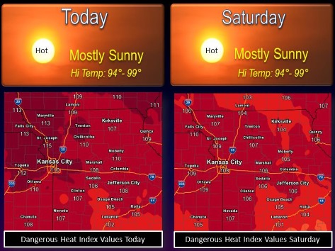
Temperatures may rise to a high of 97 today, with a heat index as high as 109 in Wyandotte County, according to the weather service.
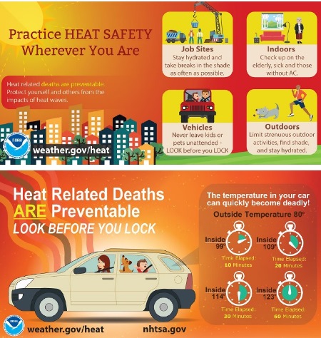
The high temperatures could quickly cause heat stress or heat stroke if precautions are not taken, the weather service said.
The very young, the elderly, those without air conditioning and those participating in strenuous outdoor activities will be the most susceptible, according to the weather service.
Car interiors may reach lethal temperatures in a matter of minutes, the weather service warned. Young children and pets should never be left unattended in cars. Always check the back seat before exiting a vehicle.
Heat illnesses are possible. Residents are advised to drink plenty of fluids, stay in an air-conditioned room, stay out of the sun and check on relatives and neighbors, according to the weather service.
A list of cooling centers in Wyandotte County is available at https://wyandotteonline.com/salvation-army-ymcas-open-cooling-shelters-today/. Residents of the Kansas City area may call 211 from their landline telephones to get information from the United Way about cooling centers.
A cold front may move into the area on Sunday, the weather service said.
Rivers in the Wyandotte County area are currently below flood stage. The Missouri River at Parkville is below flood stage, and is in action stage, according to hydrology charts. The Kansas River at 23rd Street is below flood stage and is currently below action stage.
Today, it will be sunny and hot, with a high near 97 and heat index as high as 109, the weather service said. A south southwest wind will be around 15 mph, gusting as high as 21 mph. The temperature was 85 at 9 a.m.
Tonight, it will be clear with a low of 79 and a south wind of 13 to 15 mph, gusting as high as 21 mph, according to the weather service.
Saturday, it will be sunny and hot, with a high near 97 and a heat index as high as 107, the weather service said, with a south southwest wind of 9 to 13 mph.
Saturday night, there is a 30 percent chance of showers and thunderstorms, mainly after 1 a.m., according to the weather service. It will be partly cloudy with a low of 75 and a southwest wind of 3 to 7 mph. Less than a tenth of an inch of rain is forecast.
Sunday, there is a 30 percent chance of showers and thunderstorms, mainly before 1 p.m., the weather service said. The high will be near 84 with a calm wind becoming north northeast around 6 mph in the afternoon. Less than a tenth of an inch of rain is expected.
Sunday night, there is a 20 percent chance of showers and thunderstorms, with a low of 64, according to the weather service.
Monday, it will be sunny, with a high of 82, the weather service said.
Monday night, it will be mostly clear, with a low of 61, according to the weather service.
Tuesday, it will be sunny with a high near 83, the weather service said.
Tuesday night, it will be mostly clear with a low of 61, according to the weather service.
Wednesday, it will be sunny with a high near 85, the weather service said.
Wednesday night, it will be mostly clear, with a low of 63, according to the weather service.
Thursday, it will be sunny with a high near 88, the weather service said.