Afternoon and evening storms are possible today, and the Missouri River now has dropped below flood stage in Wyandotte County.
A pattern of scattered and isolated showers now is possible each day through Saturday, according to the National Weather Service.
Severe weather is not expected, but locally, strong wind gusts will be possible each day with any storm that develops, the weather service said.
The forecast for the Fourth of July now is a 30 percent chance of showers and thunderstorms before 1 p.m., and a 20 percent chance of showers and thunderstorms that night, after 1 a.m.
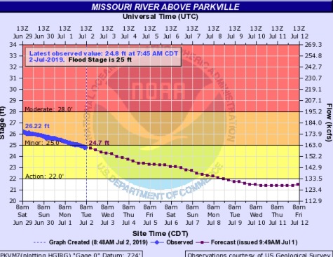
The Missouri River at Parkville, which has been flooding for some months, dropped out of flood stage today. The river gauge is on I-435 over the Missouri River, between Wyandotte County and Platte County. The river at this point was at 24.79 feet this morning, where the flood stage is 25 feet. The river crested at this point at 35.01 feet on March 23, 2019, and at 34.67 feet on June 2, 2019.
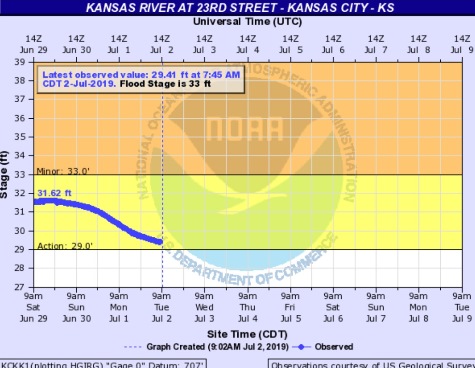
The Kansas River at 23rd Street, where the gauge is at Kansas Avenue and the state line, is currently below flood stage and at the action stage.
Today’s forecast is a30 percent chance of showers, mainly after 4 p.m., with a high near 90, the weather service said. A south southwest wind of 6 mph will become calm in the morning.
Tonight, there is a 20 percent chance of showers before 10 p.m., with a low of 73 and a calm wind, according to the weather service.
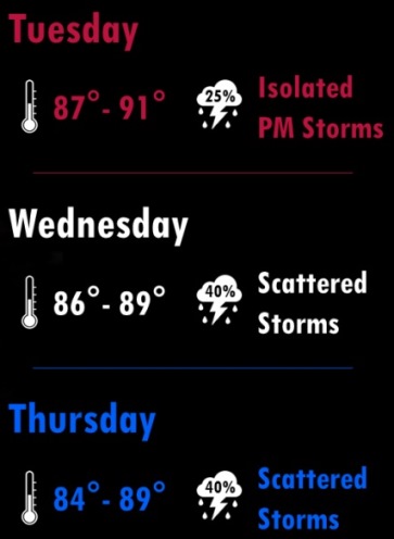
Wednesday, there is a 30 percent chance of showers and thunderstorms, mainly after 1 p.m., the weather service said. The high will be near 89, and a calm wind will become south around 6 mph in the afternoon.
Wednesday night, there is a 20 percent chance of showers and thunderstorms after 1 a.m., according to the weather service. The low will be around 72 with a south wind of 5 mph becoming calm in the evening.
On Thursday, Independence Day, there is a 30 percent chance of showers and thunderstorms, mainly before 1 p.m., the weather service said. The high will be near 89 with a south wind of 6 mph. Less than a tenth of an inch of rain is expected.
Thursday night, there is a 20 percent chance of showers and thunderstorms after 1 a.m., with a low of 73, according to the weather service.
Friday, there is a 30 percent chance of showers before 1 p.m., with a high near 90, the weather service said.
Friday night, there is a 40 percent chance of showers, with thunderstorms also possible after 1 a.m., according to the weather service. The low will be around 72.
Saturday, there is a 30 percent chance of showers and thunderstorms, with a high near 89, the weather service said.
Saturday night, it will be mostly cloudy with a low of 71, according to the weather service.
Sunday, there is a 30 percent chance of showers and thunderstorms, with a high near 89, the weather service said.
Sunday night, the low will be around 69, according to the weather service.
Monday, it will be mostly sunny, with a high near 88, the weather service said.
For more weather information, visit www.weather.gov.