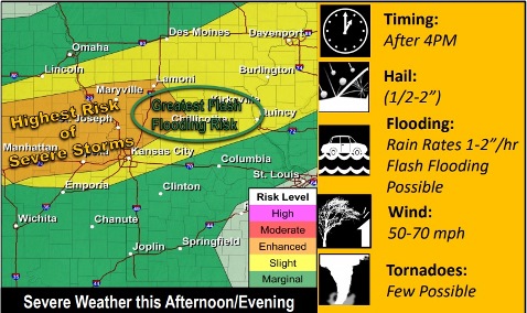
Severe storms are possible late this afternoon and evening, according to the National Weather Service. Large hail, damaging winds, flash flooding a few tornadoes are possible.
The storms will begin from 4 p.m. to 6 p.m. with all hazards, and will transition to the main hazards being damaging winds and flash flooding as the storm starts moving southeast in the evening and overnight, according to the weather service.
There are varying models of what the storms will do later today. The weather service forecast is predicting a line of storms will shift south into St. Joseph, Missouri, then it may weaken as it gets to the Kansas City area. In its initial storms, it could include supercell thunderstorms, the weather service said.
After today’s storms, the forecast is for dry weather the rest of the week.
Heat and humidity will continue today. The high will be 88 with a heat index near 91 in Wyandotte County, according to the weather service.
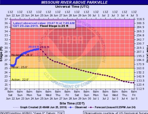
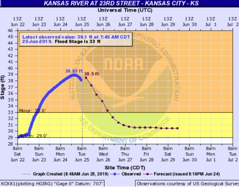
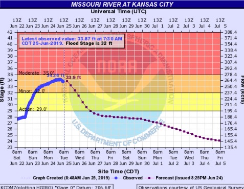
Moderate and minor river flooding, including on the Missouri and Kansas rivers, will continue in Wyandotte County. The Missouri River at Parkville, which includes Wyandotte County in its forecast area, is in moderate flood stage, while the Kansas River at the eastern border of Wyandotte County is in minor flood stage.
Today, the high will be near 88 and a southwest wind will be 9 to 11 mph, gusting as high as 21 mph, the weather service said.
Tonight, there is a 40 percent chance of showers and thunderstorms, with a low of 68, according to the weather service. A south southwest wind of 5 to 9 mph will gust as high as 18 mph. Less than a tenth of an inch of rain is expected.
Wednesday, it will be mostly sunny with a high near 88 and a south wind of 7 to 13 mph, the weather service said.
Wednesday night, it will be partly cloudy, with a low of 71, and a south wind of 6 mph, according to the weather service.
Thursday, it will be partly sunny, with a high near 90 and a south wind of 5 to 7 mph, gusting as high as 21 mph, the weather service said.
Thursday night, it will be partly cloudy, with a low of 72, according to the weather service.
Friday, it will be mostly sunny, with a high near 92, the weather service said.
Friday night, it will be mostly clear, with a low of 72, according to the weather service.
Saturday, it will be sunny with a high near 94, the weather service said.
Saturday night, it will be mostly clear with a low of 71, according to the weather service.
Sunday, it will be sunny with a high near 93, the weather service said.
Sunday night, it will be mostly clear with a low of 71, according to the weather service.
Monday, it will be mostly sunny, with a high near 92, the weather service said.
For more weather information, visit www.weather.gov.