After this morning’s lightning and wind storm around 7 a.m., another storm is possible this morning, according to the National Weather Service.
A severe thunderstorm warning has been extended for Wyandotte County through 10:45 a.m., the weather service said. Wind gusts of 60 mph are possible with this storm. Residents are advised to move to an interior room on the lowest floor of a building.
Heavy rainfall is occurring with this storm, and may result in flash flooding, the weather service said. Residents are advised to avoid flooded roadways.
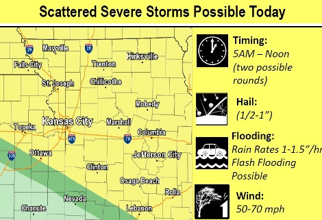
Radar showed a line of storms moving through Topeka and Manhattan, Kansas, around 8:30 and 9 a.m., and on a path to reach the Kansas City area this morning.
The weather service said the possibility of storms exists between 10 a.m. and 1 p.m., with some severe, including large hail and damaging winds.
River flooding may be aggravated and flash flooding is possible with these storms. A flood advisory is in effect until 12:45 p.m. Friday.
The storm around 7 a.m. left about 1.5 inches of rain in parts of Wyandotte County.
Today’s high will be near 88, the weather service said. The heat index could rise as high as 98. An east wind of 14 to 16 mph will become south in the afternoon, with winds gusting as high as 24 mph. Between a quarter and half-inch of rain is in the forecast.
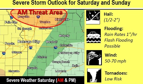
Severe storms also are possible on Saturday, the weather service said.
Tonight, there is a 20 percent chance of showers and thunderstorms, then gradually clearing, with a low of 75, according to the weather service. A south wind will be 10 to 13 mph.
Saturday, there is a 30 percent chance of showers and thunderstorms after 1 p.m., with a high near 90, the weather service said. A heat index may rise to 98. A south wind of 9 to 15 mph will gust as high as 22 mph. Less than a tenth of an inch of rain is possible.
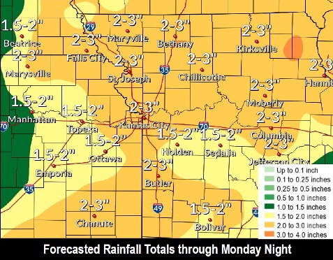
Saturday night, there is a 70 percent chance of showers and thunderstorms, with a low of 69, according to the weather service. There will be a south wind of 3 to 6 mph. Between three-quarters and one inch of rain is possible.
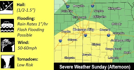
Sunday, there is a 70 percent chance of showers and thunderstorms, mainly before 1 p.m., the weather service said. The high will be near 83 with a south wind of 3 to 7 mph. Winds may gust as high as 21 mph. Between three-quarters and one inch of rain is possible.
Sunday night, there is a 30 percent chance of showers and thunderstorms, mainly before 1 a.m., according to the weather service. The low will be around 64. Less than a tenth of an inch of rain is expected.
Monday, it will be mostly sunny with a high near 83, the weather service said.
Monday night, the low will be around 64 with mostly clear skies, according to the weather service.
Tuesday, it will be sunny with a high near 89, the weather service said.
Tuesday night, it will be partly cloudy with a low of 69, according to the weather service.
Wednesday, it will be mostly sunny with a high near 89, the weather service said.
Wednesday night, it will be mostly cloudy, with a low of 70, according to the weather service.
Thursday, it will be partly sunny with a high near 89, the weather service said.
For more information, visit www.weather.gov.