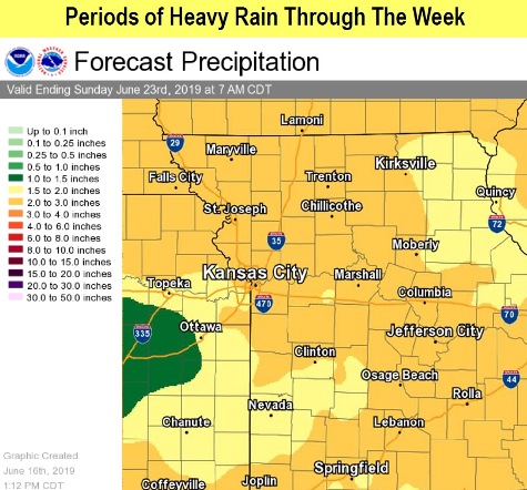
Rain is in the forecast on many days this week, according to the National Weather Service.
Today’s forecast in Wyandotte County calls for a high near 81 with partly sunny skies.
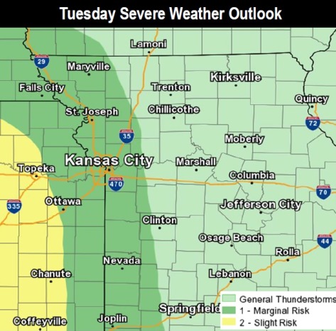
Tuesday will bring a chance of strong to isolated severe storms, with wind as the main threat, the weather service said. Heavy rain is possible Tuesday night. Rounds of scattered storms capable of heavy rain are expected through at least mid-week in the region, with an additional 1.5 to 3 inches of rain possible in some areas.
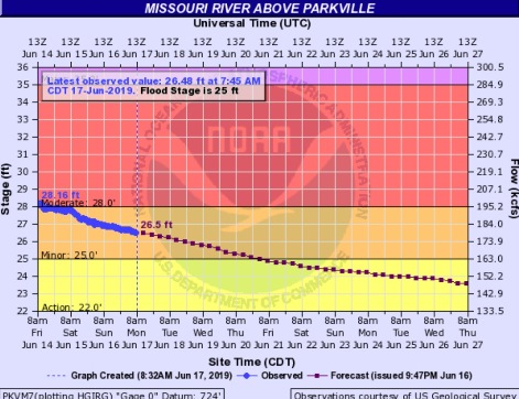
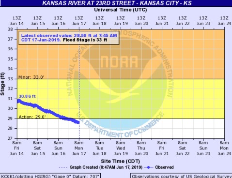
River flooding continues in the Midwest, while the river levels are declining in Wyandotte County. The Missouri River at Parkville, where the gauge is on I-435 between Wyandotte and Platte counties, now has declined out of moderate flood stage and into minor flood stage. The Kansas River at 23rd Street, where the gauge is at Kansas Avenue and the state line, is not flooding and now is below the action stage.
Today, it will be partly sunny with a high near 81 and an east northeast wind of 5 to 7 mph, the weather service said.
Tonight, it will be partly cloudy, with a low of 65 and an east northeast wind of 5 to 8 mph becoming calm in the evening, according to the weather service.
Tuesday, there is a 40 percent chance of showers and thunderstorms, mainly after 1 p.m., the weather service said. The high will be near 83 with a light and variable wind becoming south southeast around 6 mph in the morning. Less than a tenth of an inch of rain is expected.
Tuesday night, there is a 70 percent chance of showers and thunderstorms, with a low of 65, according to the weather service. A south southeast wind will be around 6 mph. Between three-quarters and 1 inch of rain are possible.
Wednesday, there is a 50 percent chance of showers and thunderstorms, with a high near 79, the weather service said. A southeast wind of 6 mph will become light and variable in the afternoon. Between a tenth and quarter-inch of rain is possible.
Wednesday night, the low will be around 62 with partly cloudy skies, according to the weather service.
Thursday, it will be mostly sunny, with a high near 85, the weather service said.
Thursday night, there is a 30 percent chance of showers and thunderstorms after 1 a.m., with a low of 67, according to the weather service.
Friday, there is a 30 percent chance of showers and thunderstorms before 1 p.m., the weather service said. The high will be near 86.
Friday night, there is a 30 percent chance of showers and thunderstorms before 1 a.m., with a low of 70, according to the weather service.
Saturday, it will be partly sunny, with a high near 86, the weather service said.
Saturday night, there is a 50 percent chance of showers and thunderstorms, with a low of 67, according to the weather service.
Sunday, there is a 40 percent chance of showers and thunderstorms, with a high near 84, the weather service said.