Storms and rain are in the forecast for Friday through Sunday evening, according to the National Weather Service.
After a day off on Monday, storms will return for Tuesday through Wednesday night, the weather service said.
The main concerns now will be for strong storms tonight, severe storms Saturday and strong storms again on Sunday, according to the weather service. With an active pattern continuing into next week, continued and aggravated river flooding will be possible in the region, the weather service said.
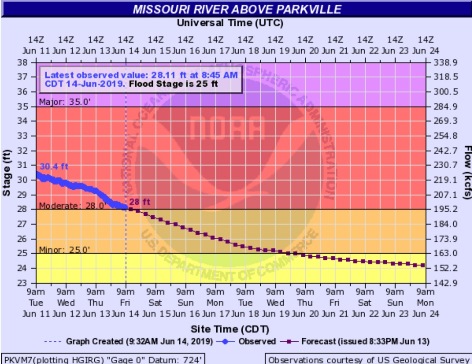
At 8:45 a.m. Friday, the Missouri River at Parkville, which also includes Wyandotte County in its forecast area, was in moderate flood stage and declining. The river was very close to dropping into minor flood stage.
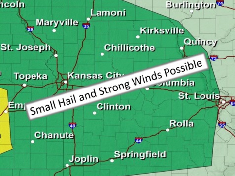
Showers earlier this morning were followed by mostly cloudy conditions. This afternoon and tonight, strong storms may develop over eastern Kansas, with a potential to be strong to severe. Small hail and strong winds are possible, according to the weather service.
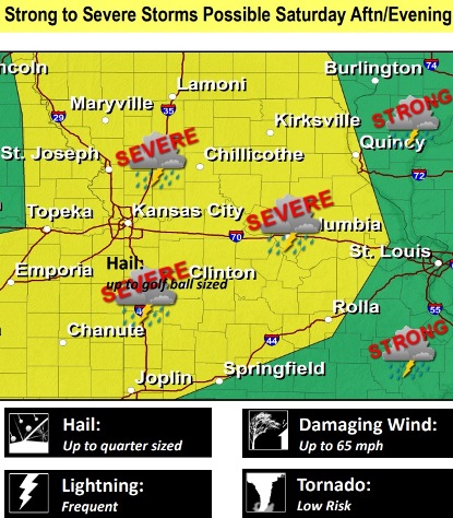
Strong to isolated severe storms are possible on Saturday, the weather service said. The main threats will be for strong to damaging winds as well as small hail up to the size of a quarter.
Today, there is a 40 percent chance of showers and thunderstorms, mainly before 3 p.m., the weather service said. The high will be near 77 with a south wind of 14 to 17 mph, gusting to 32 mph. Less than a tenth of an inch is possible.
Tonight, there is a 50 percent chance of showers and thunderstorms, mainly after 7 p.m., with a low of 68, according to the weather service. A south wind of 10 to 15 mph may gust as high as 30 mph. Less than a tenth of an inch of rain is possible.
Saturday, there is a 20 percent chance of showers and thunderstorms, mainly after 7 p.m., the weather service said. The high will be near 85, with a south southwest wind of 7 to 13 mph, gusting as high as 25 mph.
Saturday night, there is a 70 percent chance of showers and thunderstorms, mainly before 1 a.m., according to the weather service. The low will be 67 with a south southwest wind of 5 to 10 mph, becoming light in the evening. Between a quarter and half-inch of rain is possible
Sunday, there is a 40 percent chance of showers and thunderstorms, mainly before 1 a.m., the weather service said. The high will be near 83 with a calm wind. Less than a tenth of an inch of rain is expected.
Sunday night, there is a 30 percent chance of showers and thunderstorms, mostly before 1 a.m., according to the weather service. The low will be around 62. Less than a tenth of an inch of rain is expected.
Monday, it will be mostly sunny with a high near 80, the weather service said.
Monday night, it will be mostly cloudy, with a low of 60, according to the weather service.
Tuesday, there is a 30 percent chance of showers and thunderstorms after 1 p.m., the weather service said. The high will be near 80.
Tuesday night, there is a 60 percent chance of showers and thunderstorms, mainly after 1 a.m., according to the weather service. The low will be around 63.
Wednesday, there is a 40 percent chance of showers and thunderstorms, with a high near 81, the weather service said.
Wednesday night, there is a 30 percent chance of showers and thunderstorms, with a low of 64, according to the weather service.
Thursday, it will be mostly sunny with a high of 83, the weather service said.