Beautiful weather in the mid-70s is in today’s forecast, before storms move in on Friday, according to the National Weather Service.
There is a chance of rain on all of the six days from Friday through Wednesday, according to the weather service.
A high pressure system is moving east across the area, resulting in today’s unny skies, light winds and temperatures in the 70s, the weather service said.
As the high pressure moves to the east on Friday, winds will return to the south, allowing for warm air and moisture to return, the weather service said. Storms that develop in western Kansas on Thursday night, will enter the western portions of this area by Friday morning, according to forecasters.
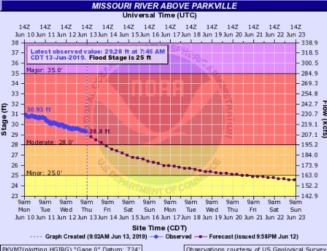
Missouri River flooding continues along the river. The Missouri River at Parkville is currently in moderate flood stage, and declining.
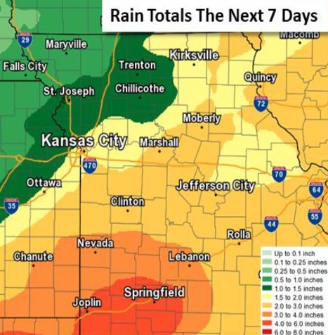
According to weather service hydrologists, the widespread rain the next several days may add up to 5 inches over the southern Osage River basin in Missouri. Wyandotte County could receive from 1.5 to 2 inches of rain over the next week, according to the forecast.
According to the weather service, the rainfall over the next week may cause smaller rivers to rise, and slow the decline of the Missouri River levels.
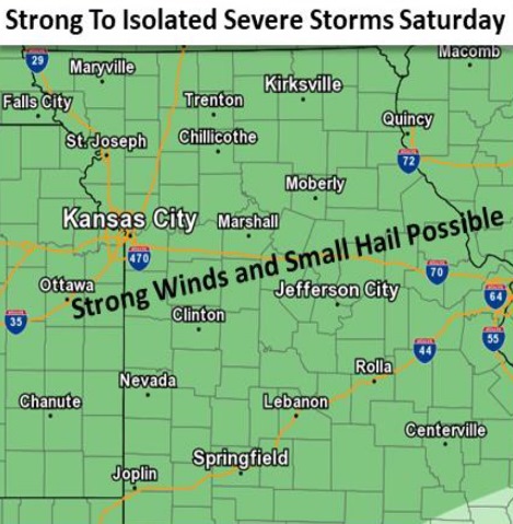
The weather service said strong to severe storms are possible on Saturday, with the possibility of damaging winds and hail up to the size of a quarter.
Today, the forecast is sunny with a high near 76 and a southwest wind of 3 to 6 mph, the weather service said.
Tonight, there will be increasing clouds, with a low of 59 and a south wind of 7 to 9 mph, according to the weather service.
Friday, there is a 40 percent chance of showers and thunderstorms, mainly between 8 a.m. and 1 p.m., the weather service said. The high will be near 78 with a south wind of 10 to 17 mph, gusting as high as 32 mph. Less than a tenth of an inch of rain is in the forecast.
Friday night, there is a 50 percent chance of showers and thunderstorms, mainly after 1 a.m., according to the weather service. The low will be around 66, with a south wind of 11 to 14 mph, gusting as high as 26 mph. Less than a tenth of an inch of rain is in the forecast.
Saturday, there is a 30 percent chance of showers and thunderstorms, mainly after 1 p.m., the weather service said. The high will be near 85 with a south southwest wind of 8 to 11 mph, gusting as high as 21 mph. Less than a tenth of an inch of rain is expected.
Saturday night, there is a 60 percent chance of showers and thunderstorms, mainly before 1 a.m., with a low of 66, according to the weather service. Between a quarter and half-inch of rain is possible.
Sunday, there is a 30 percent chance of showers and storms before 1 p.m., the weather service said. The high will be near 83.
Sunday night, there is a 30 percent chance of showers andstorm after 1 a.m., with a low of 62, according to the weather service.
Monday, there is a 30 percent chance of showers and thunderstorms, with a high near 80, the weather service said.
Monday night, it will be mostly cloudy with a low of 62, according to the weather service.
Tuesday, there is a 40 percent chance of showers and thunderstorms, with a high near 81, the weather service said.
Wednesday, there is a 40 percent chance of showers and thunderstorms, with a high near 84, the weather service said.