There is a slight chance of scattered storms and showers this afternoon, according to the National Weather Service.
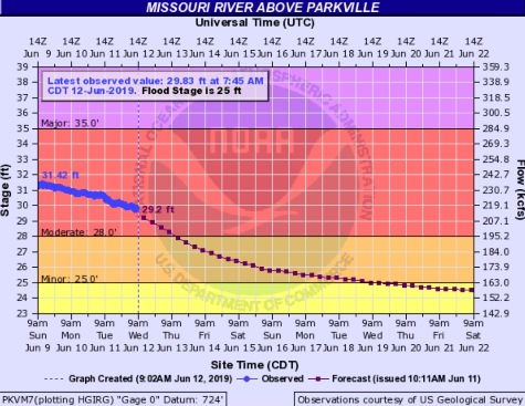
Also, river flooding continues today, with the Missouri River at Parkville, which includes Wyandotte County, in moderate flood stage and declining.
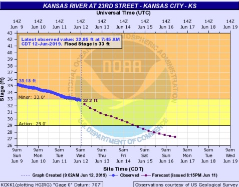
The Kansas River near the state line in Wyandotte County is declining and has just declined from minor flood stage to action stage.
More rain is in the forecast from Thursday evening through Monday. The additional rain is not expected to increase the river levels but it could mean that the rivers will remain at elevated levels longer than otherwise.
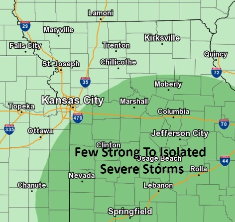
A few of the storms this afternoon could be strong, with an isolated severe storm possible, the weather service said. The storms could produce pea to quarter-sized hail and winds 40 to 60 mph. From a tenth to a quarter-inch of rain is possible.
Wyandotte County is in the least risk area for storms, with a 20 percent chance of rain today. Rain moved through the area earlier this morning, and could return again.
A slight chance of showers will begin from noon to 1 p.m. Wednesday, followed by more rain or storm chances after 1 p.m., the weather service said.
Today’s high will be near 73 with mostly cloudy skies changing to sunny, the weather service said. A north northwest wind of 5 to 15 mph will gust as high as 23 mph.
Tonight, it will be clear with a low of 50, according to the weather service. A north northwest wind of 8 to 13 mph will become light northwest after midnight, with winds gusting as high as 20 mph.
Thursday, it will be sunny with a high near 75 and a calm wind, the weather service said.
Thursday night, there will be a 20 percent chance of showers after 1 a.m., with increasing clouds and a low of 59, according to the weather service. A calm wind will become south aroun 6 mph after midnight.
Friday, there is a 40 percent chance of showers before 1 p.m., with a high near 77, the weather service said. A south wind of 6 to 11 mph will gust as high as 26 mph.
Friday night, there is a 50 percent chance of showers and thunderstorms, with a low of 65, according to the weather service. Less than a tenth of an inch is possible.
Saturday, it will be mostly cloudy with a high near 86, the weather service said.
Saturday night, there is a 40 percent chance of showers and thunderstorms, with a low of 66, according to the weather service.
Sunday, there is a 30 percent chance of showers and thunderstorms, with a high near 84, the weather service said.
Sunday night, there is a 40 percent chance of showers and thunderstorms, with a low of 65, according to the weather service.
Monday, there is a 30 percent chance of showers with a high of 82, the weather service said.
Monday night, it will be mostly cloudy with a low of 65, according to the weather service.
Tuesday, the high will be near 84 with mostly cloudy skies, the weather service said.