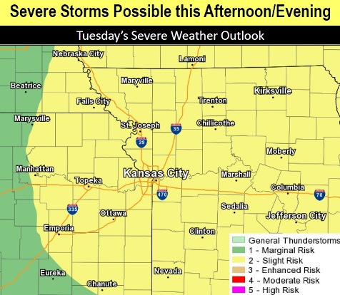
A 30 percent chance of showers and thunderstorms is in today’s forecast from the National Weather Service.
The thunderstorms could arrive mainly after 4 p.m., according to the weather service, and expected hazards may include quarter-sized to ping pong ball-sized hail, 55 to 70 mph wind gusts and an isolated tornado or two.
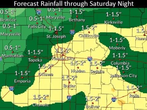
Flash flooding is possible with any rainfall today through Saturday, the weather service said.
Showers and storms are in every day’s forecast this week, through Saturday.
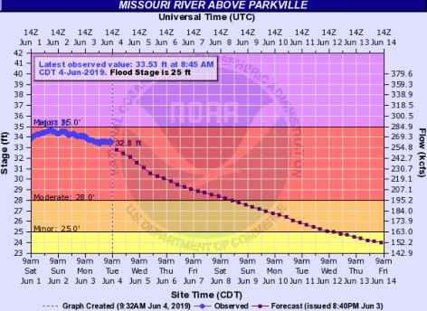
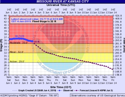
The Missouri River at Parkville, a gauge that includes Wyandotte County, is in moderate flood stage and is declining slightly, according to hydrographs.
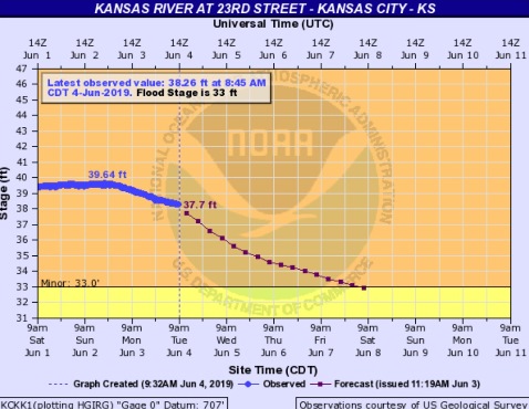
The Kansas River at 23rd Street, where the gauge is at Kansas Avenue and the state line, is in minor flood stage and is declining slightly.
Residents who come upon any flooded streets are urged to turn around and not try to drive through it, according to the weather service.
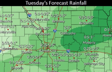
Today, there is a 30 percent chance of showers and thunderstorms, mainly after 4 p.m., the weather service said. The high will be near 85 with a south wind of 6 to 11 mph. Between a tenth and quarter-inch of rain is possible.
Tonight, there is a 40 percent chance of showers and thunderstorms, with a low of 68, and a southwest wind of 7 to 10 mph, according to the weather service. Between a tenth and quarter-inch of rain is possible.
Wednesday, there is a 30 percent chance of showers and thunderstorms after 1 p.m., with a high near 88 and a southwest wind of 7 mph becoming west northwest in the afternoon, the weather service said. Less than a tenth of an inch of rain is expected.
Wednesday night, there is a 30 percent chance of showers and thunderstorms, with a low of 68, according to the weather service. A north wind of 6 mph will become light and variable after midnight. Less than a tenth of an inch of rain is expected.
Thursday, there is a 40 percent chance of showers and thunderstorms, with a high near 83 and an east northeast wind of 3 to 8 mph, the weather service said. Less than a tenth of an inch of rain is expected.
Thursday night, there is a 40 percent chance of showers and thunderstorms, with a low of 66, according to the weather service. Between a quarter and half-inch of rain is possible.
Friday, there is a 50 percent chance of showers and thunderstorms, with a high near 79, the weather service said.
Friday night, there is a 30 percent chance of showers and thunderstorms, with a low of 66, according to the weather service.
Saturday, there is a 50 percent chance of showers and thunderstorms, with a high near 81, the weather service said.
Saturday night, it will be mostly cloudy, with a low of 65, according to the weather service.
Sunday, it will be partly sunny with a high near 84, the weather service said.
Sunday night, the low will be around 64 with mostly cloudy skies, according to the weather service.
Monday, it will be mostly sunny, with a high near 80, the weather service said.