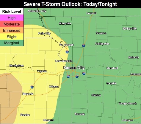
A few strong to marginally severe storms are possible late this evening and tonight, according to the National Weather Service.
A thunderstorm cluster may develop in central and eastern Kansas and move toward Missouri, the weather service said. The most likely time for storms to arrive will be after 8 p.m.
Last night, tornadoes caused damage to Jefferson City, Missouri, where there was extensive damage and nine persons were hospitalized, according to the Missouri Public Safety Department. In another tornado Wednesday, three persons were reported killed in Golden, Missouri. On Tuesday, a tornado was sighted in Atchison County near Effingham, Kansas, according to the weather service.
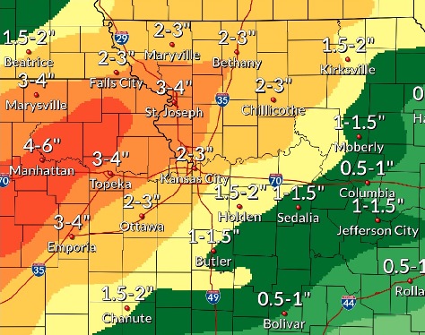
Heavy rain will be possible today, including in areas with already saturated grounds, the weather service said.
River flooding concerns remain, with new heavy rainfall prolonging flooding along the Missouri River and leading to new flooding on its tributaries, according to the weather service.
The Missouri River above Parkville, which includes the Wyandotte County area, is currently in minor flood stage and declining, according to hydrology charts. This gauge is on I-435 over the Missouri River, between Wyandotte County and Platte County.
The Kansas River at 23rd Street, where the gauge is at Kansas Avenue and the state line, is currently in minor flood stage and declining, hydrology charts showed.
The Missouri River at Kansas City, where the gauge is at U.S. 169 at the Missouri River near the City Market in Kansas City, Missouri, is currently in the action stage, which is below the minor flood stage, according to hydrology charts.
More severe storms are possible Saturday and Sunday, according to the weather service.
Today, a 20 percent chance of showers and thunderstorms is possible after 1 p.m., with a high near 76. A light and variable wind will become east 5 to 7 mph in the morning, the weather service said.
Tonight, there is a 40 percent chance of showers and thunderstorms, mainly after 8 p.m., according to the weather service. The low will be around 67. An east wind will be around 8 mph, becoming south after midnight. New rainfall between a tenth and quarter-inch is possible.
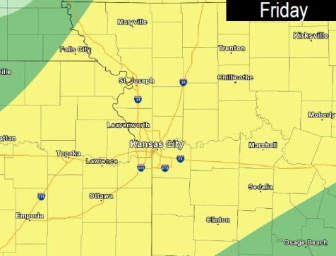
Friday, there is a 50 percent chance of showers and thunderstorms, with a high near 81, the weather service said. A south southwest wind of 10 to 13 mph will gust as high as 18 mph. Between a tenth and quarter-inch of rain is possible.
Friday night, there is an 80 percent chance of showers and thunderstorms, mainly between 1 a.m. and 4 a.m., then showers and possibly a thunderstorm after 4 a.m., according to the weather service. The low will be around 66. A south southwest wind of 8 to 13 mph will gust as high as 18 mph. Between 1 and 2 inches of rain are possible.
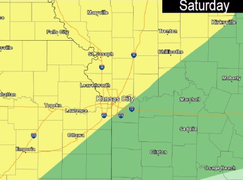
Saturday, there is a 70 percent chance of showers and thunderstorms, mainly before 1 p.m., with a high near 79, the weather service said. A south southwest wind of 8 to 13 mph will gust as high as 23 mph. Between a half and three-quarters of an inch of rain is possible.
Saturday night, there is an 80 percent chance of showers and thunderstorms, then a chance of showers and a possible thunderstorm after 1 a.m., according to the weather service. The low will be 65. Between a quarter and half-inch of rain is possible.
Sunday, there is a 40 percent chance of showers and thunderstorms, with a high near 81, the weather service said.
Sunday night, there is a 40 percent chance of showers and thunderstorms after 1 a.m., with a low of 67, according to the weather service.
Monday, Memorial Day, there is a 30 percent chance of showers and thunderstorms before 1 p.m., with a high near 83, the weather service said.
Monday night, the low will be around 67, according to the weather service.
Tuesday, there is a 50 percent chance of showers and thunderstorms, with a high near 80, the weather service said.
Tuesday night, there is a 40 percent chance of showers and thunderstorms, with a low of 58, according to the weather service.
Wednesday, it will be mostly sunny, with a high near 75, the weather service said.