Flash flooding is a major concern this morning and through the day, as there is heavy rain today, according to the National Weather Service.
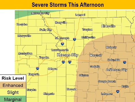
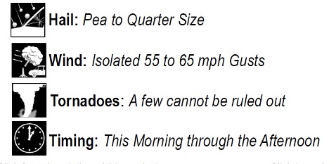
Severe weather is possible this afternoon, the weather service said. Wyandotte County is in an area of slight risk for severe weather, with the focus for more severe weather to the east and south of the Kansas City area. Hail and damaging winds are possible with the storm.
New heavy rainfall will prolong flooding along the Missouri River and lead to new flooding on tributaries, according to the weather service.
A flash flood warning is in effect for Wyandotte County from 8:51 a.m. until 7 p.m. Tuesday, May 21, according to the weather service.
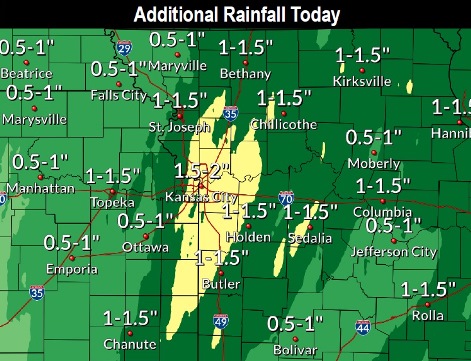
Heavy rain is falling, on top of two to four inches of rain that have already fallen. Another one or two inches of rain may fall. Flash flooding is expected in Bonner Springs, Edwardsville and parts of Wyandotte County.
Excessive runoff from heavy rainfall may cause flooding of small creeks and streams, urban areas, highways, streets and underpasses as well as other drainage areas and low-lying spots.
A flood warning is in effect from 9 a.m. May 21 through noon May 21, the weather service said.
At 9:04 a.m., radar indicated heavy rain that will cause flooding, the weather service said. Up to 2 inches of rain have already fallen.
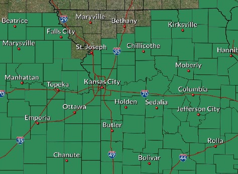
Kansas City, Kansas, is one of the areas along the river that will experience flooding.
Drivers encountering flooded roads should turn around and take another route, according to the weather service.
The Kansas River at 23rd Street, the Missouri River at Kansas City and the Missouri River at Parkville, all affecting Wyandotte County, also are under a flood warning,
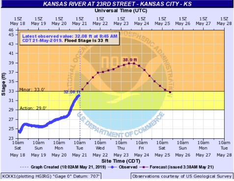
The Kansas River at 23rd Street, where the gauge is at Kansas Avenue and the state line, is projected to rise above flood stage by Tuesday afternoon and continue to rise to near 38.9 feet by Thursday evening. The river will fall below flood stage, which is 33 feet, by Saturday afternoon, according to the weather service. Minor flooding is forecast.
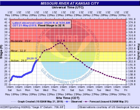
The Missouri River at Kansas City is forecast to rise above flood stage by Wednesday morning and continue to rise to near 34.7 feet by early Friday morning, according to the weather service. The river will fall below flood stage, which is 32 feet, by early Saturday morning. Minor flooding is forecast. This gauge is at U.S. 169 near I-70 in Kansas City, Missouri, near the City Market.
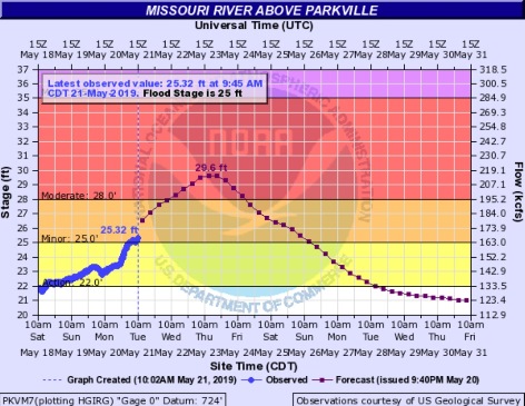
The Missouri River at Parkville, where the gauge is at I-435 over the Missouri River between Wyandotte County and Platte County, is forecast to have moderate flooding. It will rise above flood stage by Tuesday morning and continue to rise to near 29.6 feet by Thursday afternoon, the weather service said. The river may fall below flood stage by early Sunday afternoon. Flood stage is 25 feet at that gauge.
Today, showers and thunderstorms will continue, mainly before 5 p.m., the weather service said. Some of the storms may produce heavy rain. The high will be near 69 with an east northeast wind of 10 to 20 mph becoming southeast in the afternoon. Winds may gust as high as 32 mph. New rainfall will be between 1 and 2 inches.
Tonight, there is a 10 percent chance of showers and thunderstorms before 7 p.m., with a low of 55, according to the weather service. A south wind of 10 to 17 mph will gust as high as 25 mph.
Wednesday, it will be sunny with a high near 80, the weather service said. A south southwest wind of 8 to 13 mph will gust as high as 23 mph.
Wednesday night, there is a 50 percent chance of showers and thunderstorms, with a low of 63. A south southwest wind of 5 to 8 mph will become light and variable. Between a quarter and half-inch of rain is possible.
Thursday, there is a 40 percent chance of showers, with thunderstorms also possible after 1 p.m., the weather service said. The high will be near 82. A south wind of 6 to 10 mph will gust as high as 18 mph. Less than a tenth of an inch of rain is expected.
Thursday night, there is a 20 percent chance of showers and thunderstorms after 1 a.m., with a low around 70, according to the weather service.
Friday, there is a 40 percent chance of showers and thunderstorms, with a high near 80, the weather service said.
Friday night, there is an 80 percent chance of showers and thunderstorms, with a low of 65, according to the weather service.
Saturday, there is a 60 percent chance of showers and thunderstorms, mainly before 1 p.m., the weather service said. The high will be near 79.
Saturday night, there is a 70 percent chance of showers and thunderstorms, mainly after 1 a.m., with a low of 65, according to the weather service.
Sunday, there is a 40 percent chance of showers and thunderstorms, with a high near 80, the weather service said.
Sunday night, there is a 40 percent chance of showers, with a low of 65, according to the weather service.
On Monday, Memorial Day, there is a 40 percent chance of showers, with a high near 80, the weather service said.
For more weather information, visit www.weather.gov or listen to a weather radio.