After today’s hot and humid weather, multiple rounds of thunderstorms will be possible from Friday night into next week, according to the National Weather Service.
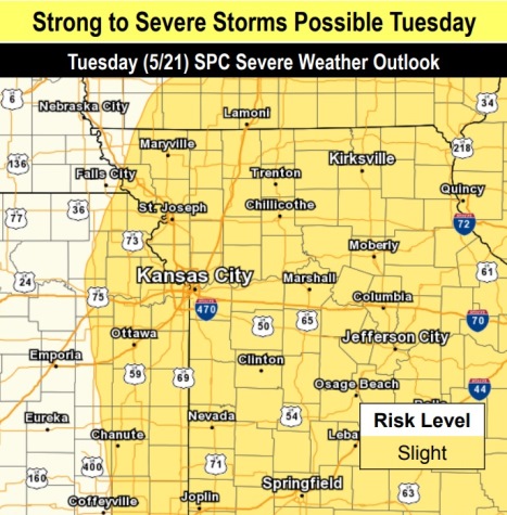
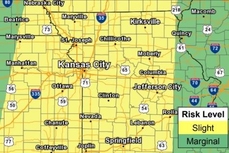
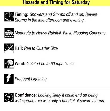
Isolated severe storms are possible with the activity Saturday and next week, the weather service said.
Hot and humid conditions are expected Thursday with highs in the lower 90s and a heat index in the low to mid 90s, according to the weather service.
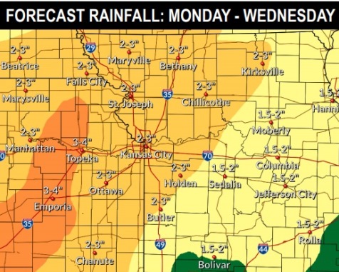
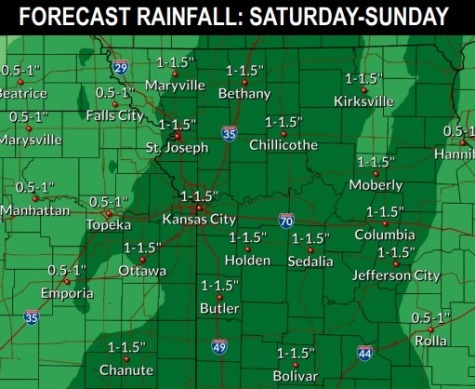
New flooding issues as well as renewed river flooding are possible with the storms starting with this weekend, the weather service said.
The ongoing river flooding is declining today, however, the Missouri River may remain in flood for several days at some cities, with the new storms, according to the weather service.
The Missouri River at Parkville, with a gauge on I-435 between Wyandotte and Platte counties, is currently below flood stage, according to hydrology charts. It is in action stage today and declining.
Today, it will be sunny, with a high near 91 and a south southwest wind of 10 to 16 mph, gusting as high as 30 mph, the weather service said.
Tonight, it will be mostly clear, with a low of 68 and a south southwest wind of 13 to 15 mph, gusting to 22 mph, according to the weather service.
Friday, it will be mostly sunny, with a high near 85 and a south southwest wind of 13 to 16 mph, gusting as high as 30 mph, the weather service said.
Friday night, there is a 30 percent chance of showers and thunderstorms after 1 a.m., according to the weather service. The low will be around 68 with a south wind of 13 to 15 mph, gusting as high as 26 mph. Less than a tenth of an inch of rain is expected.
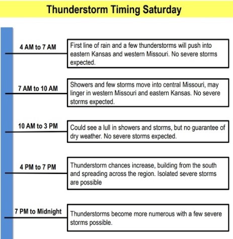
Saturday, there is a 60 percent chance of showers and thunderstorms, mainly after 1 p.m., the weather service said. The high will be near 78 with a south wind of 13 to 16 mph, gusting as high as 30 mph. Between a quarter and half-inch of rain is possible.
Saturday night, there is an 80 percent chance of showers and thunderstorms, with a low of 58, according to the weather service. Between three-quarters and one inch of rain is possible.
Sunday, it will be partly sunny, with a high near 69, the weather service said.
Sunday night, it will be partly cloudy, with a low of 48, according to the weather service.
Monday, it will be partly sunny, with a high near 68, the weather service said.
Monday night, there is a 70 percent chance of showers and thunderstorms, mainly after 1 a.m. The low will be around 59.
Tuesday, there is a 70 percent chance of showers and thunderstorms, with a high near 72, the weather service said.
Tuesday night, it will be mostly cloudy, with a low of 55, according to the weather service.
Wednesday, it will be mostly sunny, with a high near 73, the weather service said.
For more weather information, visit www.weather.gov.