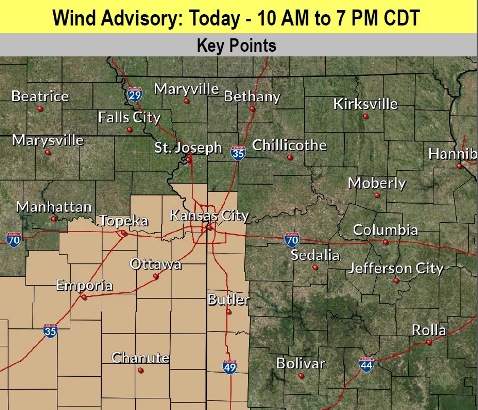
A wind advisory has been issued for Wyandotte County from 10 a.m. to 7 p.m. Wednesday, according to the National Weather Service.
South winds of 25 to 35 mph are possible, with gusts to 50 mph, the weather service said. Today’s high will be about 82.
Travel along east to west highways such as I-70 will be very difficult, especially for high-profile vehicles and trailers, according to the weather service. The strong limbs also could cause tree limbs to break. Any unsecured lightweight items could become flying objects.
Residents are advised to use extra caution today when driving, according to the weather service.
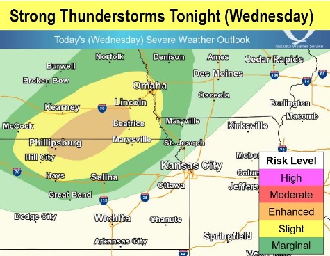
Also in today’s forecast is a thunderstorm that is expected to miss Wyandotte County, but may affect areas to the north.
Because of the high winds, fire danger also will be high day, although with the relative humidity level a warning has not been issued. Burning should be completely avoided today, according to the weather service, as anything that does ignite will quickly burn out of control.
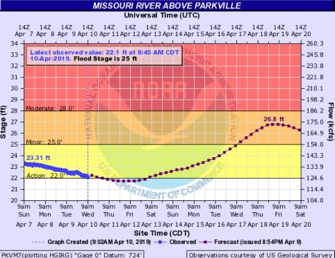
Flooding concerns will return to the Kansas City area by the end of next week, the weather service predicted. A flood warning has been issued for 9 a.m. April 17 for the Missouri River at Parkville, affecting Wyandotte, Leavenworth and Platte counties, according to the weather service.
The National Weather Service is forecasting significant snow and rain over the Missouri River basin area in South Dakota later this week, that may affect the river here next week.
A cold front will be forced through the area late tonight into early Thursday morning, according to the weather service. It appears this event now will remain dry, and it will usher in much cooler temperatures, with temperatures falling through the day.
Highs will occur in the 50s in the morning on Thursday to the west and in the 60s to the east.
Some areas may see a few snowflakes early Friday morning, however, it currently looks unlikely here with the storm system moving to the north. Highs on Friday will be in the upper 40s to mid-50s, while Saturday morning lows could be in the low to mid-30s. Sensitive vegetation may need to be protected, the weather service said.
Today, expect partly sunny skies, with a high near 82. A south wind of 13 to 22 mph will gust as high as 43 mph, the weather service said.
Tonight, the low will be around 52 with partly cloudy skies, according to the weather service. A south wind of 16 to 23 mph may gust as high as 33 mph.
Thursday, it will be partly sunny, with temperatures falling to around 50 by 5 p.m., the weather service said. A southwest wind of 17 to 23 mph will gust as high as 36 mph.
Friday, it will be mostly sunny with a high near 53, the weather service said. A west wind of 16 mph may gust as high as 26 mph.
Friday night, it will be partly cloudy with a low of 35, according to the weather service.
Saturday, it will be mostly sunny with a high near 54, the weather service said.
Saturday night, the low will be around 38 with a 60 percent chance of showers after 1 a.m., according to the weather service.
Sunday, there is a 30 percent chance of showers before 1 p.m., with a high near 55, the weather service said.
Sunday night, it will be partly cloudy, with a low of 41, according to the weather service.
Monday, it will be sunny with a high near 68, the weather service said.
Monday night, it will be partly cloudy with a low of 54, according to the weather service.
Tuesday, it will be partly sunny, with a high near 71, the weather service said.